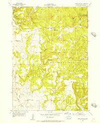
1955 Map of Jewel Cave NW
USGS Topo · Published 1956About this map
The Black Hills National Forest defines this high-elevation landscape in the mid-1950s, a rugged area of limestone canyons and timber managed by the Tepee Ranger Station. This specific terrain shows the rural educational landscape of the era, marking the location of the Lauzon Sch in the southern reaches and the Elk Mountain Sch (Abandoned) further north. The northwestern corner of Jewel Cave National Monument enters the sheet, while private landholdings like the X-T Ranch and Soper Ranch sit alongside remote settlements like Gillette. Water sources were critical for the cattle operations of the day, as evidenced by named draws and springs including Jumpoff Springs, Lost Spring, and Baldwin Spring. The map's production involved the Atomic Energy Commission, reflecting the era's interest in mineral resources within the Black Hills.
Find a feature on this map
19 named features on this map. Tap any name to fly to it.
Don’t see what you’re looking for? This feature index may not catch every label — zoom into the map to look around manually.
Map Details
Editions of this 1955 Jewel Cave NW Map
4 editions found

Other maps of this area

1896 · Harney Peak
USGS Topo · 1:125,000

1899 · Newcastle
USGS Topo · 1:125,000

1901 · Harney Peak
USGS Topo · 1:125,000

1901 · Newcastle
USGS Topo · 1:125,000

1951 · Dewey
USGS Topo · 1:24,000

1951 · Fanny Peak
USGS Topo · 1:24,000

1951 · Clifton
USGS Topo · 1:24,000

1954 · Jewel Cave SE
USGS Topo · 1:24,000
1954 · Jewel Cave SW
USGS Topo · 1:24,000

1955 · Dead Horse Flats
USGS Topo · 1:24,000