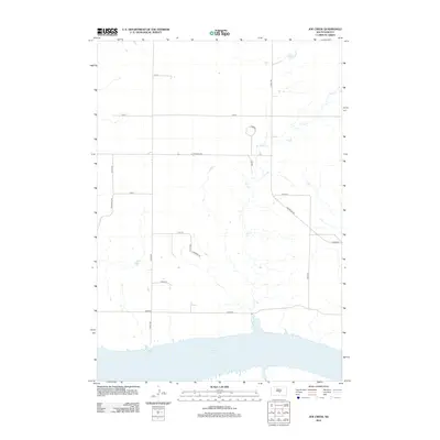
2012 Map of Joe Creek
USGS Topo · Published 2012About this map
Lake Sharpe dominates the southern edge of this landscape, its expansive waters meeting a network of drainage systems that define the local topography. The primary waterway, Joe Cr, meanders northward from the lake, carving a path through the plains of the Big Bend District. The rural character of the area is etched in a grid of section-line roads, including 314th Ave and 218 St, which facilitate access to the surrounding agricultural land.
Find a feature on this map
21 named features on this map. Tap any name to fly to it.
Don’t see what you’re looking for? This feature index may not catch every label — zoom into the map to look around manually.
Map Details
Editions of this 2012 Joe Creek Map
This is the sole edition of this map. No revisions or reprints were ever made.
Other maps of this area

1953 · Huron
USGS Topo · 1:250,000

1954 · Huron
USGS Topo · 1:250,000

1966 · Lower Brule NW
USGS Topo · 1:24,000

1966 · Joe Creek
USGS Topo · 1:24,000

1966 · Joe Creek NW
USGS Topo · 1:24,000

1966 · Lower Brule SW
USGS Topo · 1:24,000

1966 · Joe Creek SE
USGS Topo · 1:24,000
1966 · Joe Creek SW
USGS Topo · 1:24,000

1973 · De Grey SE
USGS Topo · 1:24,000
1973 · De Grey
USGS Topo · 1:24,000