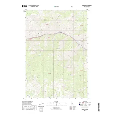
2020 Map of Johnson Butte
USGS Topo · Published 2020About this map
The Salmon River carves a deep path through central Idaho, forming the natural boundary between the Nez Perce National Forest to the north and the Payette National Forest to the south. This 2020 survey documents a dramatic riverine landscape defined by hazardous whitewater, including Dried Meat Rapids, Little Goulder Rapids, Bone Creek Rapids, and Canopener Rapids. Along the riverbank, Sheep Creek Bar serves as one of the few named level sites in this steep terrain. The interior is marked by significant topographical landmarks such as Johnson Butte, the high peak of Marshall Mtn, and the high-altitude Bear Lake. A network of backcountry access points is visible, including Johnson Saddle, Canada Saddle, and Beartrap Saddle, alongside Natl Forest Develop Road 318 Rd and Corduroy Meadows Rd, which provide passage through the high-elevation ridges.
Find a feature on this map
44 named features on this map. Tap any name to fly to it.
Don’t see what you’re looking for? This feature index may not catch every label — zoom into the map to look around manually.
Map Details
Editions of this 2020 Johnson Butte Map
This is the sole edition of this map. No revisions or reprints were ever made.
Other maps of this area

1931 · Buffalo Hump
USGS Topo · 1:125,000

1934 · Buffalo Hump
USGS Topo · 1:125,000

1956 · Burgdorf
USGS Topo · 1:62,500

1956 · Warren
USGS Topo · 1:62,500

1956 · Elk City
USGS Topo · 1:250,000

1960 · Elk City
USGS Topo · 1:250,000

1963 · Hanover Mtn.
USGS Topo · 1:24,000

1963 · Marble Butte
USGS Topo · 1:24,000

1979 · Buffalo Hump
USGS Topo · 1:24,000

1981 · Warren
USGS Topo · 1:100,000