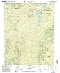
1999 Map of Johnson Mountain
USGS Topo · Published 2002About this map
Council Bluff Lake serves as a central hydrological feature on the border of Washington and Iron counties, where the Council Bluff Lake Dam regulates the Big River. The area is deeply marked by the legacy of the Mark Twain National Forest, containing a network of hollows such as Guyer Hollow and Cave Hollow that feed into Ottery Creek and the Middle Fork Black River. The map captures a transition in land use, showing the Enough site submerged or repurposed for recreation with the Enough Boat Launch.
Find a feature on this map
36 named features on this map. Tap any name to fly to it.
Don’t see what you’re looking for? This feature index may not catch every label — zoom into the map to look around manually.
Map Details
Editions of this 1999 Johnson Mountain Map
This is the sole edition of this map. No revisions or reprints were ever made.
Other maps of this area

1906 · Potosi
USGS Topo · 1:62,500

1924 · Edgehill
USGS Topo · 1:62,500

1926 · Edgehill
USGS Topo · 1:62,500

1943 · Berryman
USGS Topo · 1:62,500

1943 · Boss
USGS Topo · 1:62,500

1945 · Berryman
USGS Topo · 1:62,500

1946 · Boss
USGS Topo · 1:62,500

1949 · Rolla
USGS Topo · 1:250,000

1953 · Rolla
USGS Topo · 1:250,000

1954 · Rolla
USGS Topo · 1:250,000