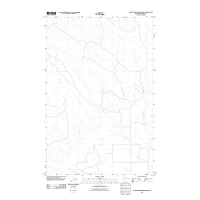
2011 Map of Johnson Reservoir NW
USGS Topo · Published 2011About this map
The high plains of Dawson County are defined by a complex network of intermittent drainages and ranch access roads. The Middle Fork Deer Creek and North Fork Deer Creek carve through this landscape, highlighting the importance of seasonal water sources in this part of Montana. These waterways, along with Bluff Creek and Corral Creek, dictate the geography of a region shaped more by hydrology than dense settlement. Human impact is visible primarily through transportation corridors like Road 427, providing a view of the rural infrastructure at the start of the 2010s. The presence of Brush Creek further illustrates the fine-grained hydrographic detail recorded in this USGS study, documenting the local topography before subsequent changes in land use or drainage patterns.
Find a feature on this map
6 named features on this map. Tap any name to fly to it.
Don’t see what you’re looking for? This feature index may not catch every label — zoom into the map to look around manually.
Map Details
Editions of this 2011 Johnson Reservoir NW Map
This is the sole edition of this map. No revisions or reprints were ever made.
Other maps of this area

1954 · Glendive
USGS Topo · 1:250,000

1957 · Glendive
USGS Topo · 1:250,000

1958 · Glendive
USGS Topo · 1:250,000

1982 · Circle
USGS Topo · 1:100,000

1983 · Johnson Reservoir NW
USGS Topo · 1:24,000
1983 · Johnson Reservoir
USGS Topo · 1:24,000

1983 · Olson Coulee South
USGS Topo · 1:24,000

1983 · Deer Creek Church
USGS Topo · 1:24,000

1983 · Circle Reservoir
USGS Topo · 1:24,000
1983 · Johnson Reservoir NE
USGS Topo · 1:24,000