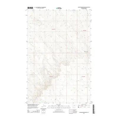
2014 Map of Johnson Reservoir NW
USGS Topo · Published 2014About this map
Big Sheep Mountains dominate the eastern landscape of this Dawson County region, defining a terrain shaped by the intricate drainage systems of the Yellowstone River watershed. This 2014 survey documents a network of seasonal watercourses and rural corridors, most notably Bluff Cr which meanders through the central and western sections. The map reveals the precise township and range grid system, including t20n r51e and t19n r51e, illustrating how land division was historically organized in this part of Montana. To the south and east, the headwaters of the Deer Creek system are visible via N Fork Deer Cr and Middle Fork Deer Cr. Local transportation is anchored by rural routes such as Mt-470 and Road 452, providing insight into the modern infrastructure that connects these high prairie ranchlands.
Find a feature on this map
14 named features on this map. Tap any name to fly to it.
Don’t see what you’re looking for? This feature index may not catch every label — zoom into the map to look around manually.
Map Details
Editions of this 2014 Johnson Reservoir NW Map
This is the sole edition of this map. No revisions or reprints were ever made.
Other maps of this area

1954 · Glendive
USGS Topo · 1:250,000

1957 · Glendive
USGS Topo · 1:250,000

1958 · Glendive
USGS Topo · 1:250,000

1982 · Circle
USGS Topo · 1:100,000

1983 · Johnson Reservoir NW
USGS Topo · 1:24,000
1983 · Johnson Reservoir
USGS Topo · 1:24,000

1983 · Olson Coulee South
USGS Topo · 1:24,000

1983 · Deer Creek Church
USGS Topo · 1:24,000

1983 · Circle Reservoir
USGS Topo · 1:24,000
1983 · Johnson Reservoir NE
USGS Topo · 1:24,000