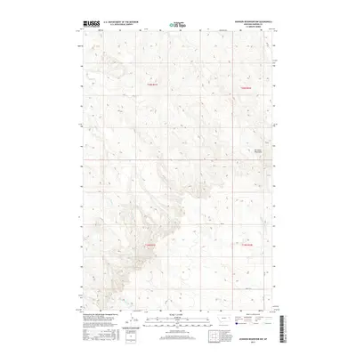
2017 Map of Johnson Reservoir NW
USGS Topo · Published 2017About this map
The Big Sheep Mountains dominate this high-plains landscape in Dawson County, where the terrain is deeply dissected by a network of seasonal drainages. Waterways such as Bluff Cr, Brush Cr, and the Middle Fork Deer Cr carve through the land, illustrating the complex erosional patterns characteristic of this part of Montana. The map provides a look at the rural infrastructure and land divisions within t20n r51e, t20n r52e, t19n r51e, and t19n r52e. Local movement across these ridges and valleys is facilitated by a grid of rural routes including Fas 470, Rd 452, and the notably named Abac 13-W. This survey is particularly useful for understanding the exact positioning of creek beds and topographic elevations in an area where the natural drainage system is the primary landmark.
Find a feature on this map
15 named features on this map. Tap any name to fly to it.
Don’t see what you’re looking for? This feature index may not catch every label — zoom into the map to look around manually.
Map Details
Editions of this 2017 Johnson Reservoir NW Map
This is the sole edition of this map. No revisions or reprints were ever made.
Other maps of this area

1954 · Glendive
USGS Topo · 1:250,000

1957 · Glendive
USGS Topo · 1:250,000

1958 · Glendive
USGS Topo · 1:250,000

1982 · Circle
USGS Topo · 1:100,000

1983 · Johnson Reservoir NW
USGS Topo · 1:24,000
1983 · Johnson Reservoir
USGS Topo · 1:24,000

1983 · Olson Coulee South
USGS Topo · 1:24,000

1983 · Deer Creek Church
USGS Topo · 1:24,000

1983 · Circle Reservoir
USGS Topo · 1:24,000
1983 · Johnson Reservoir NE
USGS Topo · 1:24,000