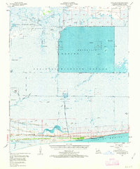
1955 Map of Johnsons Bayou
USGS Topo · Published 1963About this map
Sabine National Wildlife Refuge dominates this coastal landscape in Cameron Parish, where the complex hydrology of Southwest Louisiana meets the Gulf of Mexico. The area is characterized by a sophisticated network of man-made waterways like Starks Canal, Magnolia Canal, and the Burton Sutton Canal, which support both water management and the local energy industry. The extractive economy of the mid-century is evident through the Burton Oil Field and the Cameron Meadows Oil and Gas Field.
Find a feature on this map
71 named features on this map. Tap any name to fly to it.
Don’t see what you’re looking for? This feature index may not catch every label — zoom into the map to look around manually.
Map Details
Editions of this 1955 Johnsons Bayou Map
3 editions found
Other maps of this area

1932 · Sabine Pass NE
USGS Topo · 1:31,680

1932 · Orange
USGS Topo · 1:62,500

1932 · Port Arthur NE
USGS Topo · 1:31,680

1934 · Johnsons Bayou
USGS Topo · 1:24,000

1934 · Holly Beach
USGS Topo · 1:24,000

1934 · Peveto Beach
USGS Topo · 1:24,000

1934 · Greens Bayou
USGS Topo · 1:24,000

1934 · Browns Lake
USGS Topo · 1:24,000

1934 · Five Lakes
USGS Topo · 1:24,000

1935 · Peveto Beach
USGS Topo · 1:31,680