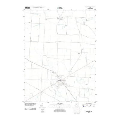
2010 Map of Johnstown
USGS Topo · Published 2010About this map
Johnstown serves as the primary hub of this Licking County landscape, where the confluence of several rural routes and the Raccoon Creek drainage define the local geography. To the north, the village of Croton sits near the headwaters of the Otter Fork Licking River, an area marked by historic infrastructure like the Belle Hall Bridge and the P E Grubb Lake Dam. The map reveals a high density of rural burial sites, including the Patterson Cemetery, Gould Cemetery, and Green Hill Cemetery, which offer valuable locations for genealogical research into the families of Monroe and Bennington Townships. Small settlements like Twelve Corners and Willison Corners punctuate the grid of farm roads, while the presence of McKnight Airport and the Johnstown Post Office reflect the area's continued role as a regional center of commerce and transit in the early twenty-first century.
Find a feature on this map
62 named features on this map. Tap any name to fly to it.
Don’t see what you’re looking for? This feature index may not catch every label — zoom into the map to look around manually.
Map Details
Editions of this 2010 Johnstown Map
This is the sole edition of this map. No revisions or reprints were ever made.
Other maps of this area

1902 · Westerville
USGS Topo · 1:62,500

1904 · Westerville
USGS Topo · 1:62,500

1908 · Granville
USGS Topo · 1:62,500

1910 · Granville
USGS Topo · 1:62,500

1915 · Marengo
USGS Topo · 1:62,500

1915 · Fredericktown
USGS Topo · 1:62,500

1943 · Marengo
USGS Topo · 1:62,500

1943 · Fredericktown
USGS Topo · 1:62,500

1950 · Marion
USGS Topo · 1:250,000
1955 · Sunbury
USGS Topo · 1:24,000