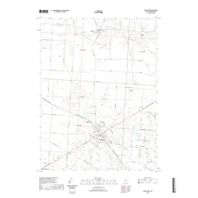
2019 Map of Johnstown
USGS Topo · Published 2019About this map
Johnstown anchors the southern portion of this Licking County landscape, where the convergence of the Johnstown-Utica Rd and Johnstown-Alexandria Rd reflects a long-established regional transportation hub. Northward, the village of Croton and the settlement of Hartford sit near the Otter Fork Licking River, a waterway that defined early navigation and industry in the area. The map reveals a dense network of family-named burial grounds, including Patterson Cem and Gould Cem, which offer significant value for genealogical research. The terrain is characterized by several water systems, from the drainage of Raccoon Creek to localized features like P E Grubb Lake. To the east, the rural community of Concord remains connected by a grid of township highways, while McKnight Airport suggests the continued modern utility of these open fields.
Find a feature on this map
97 named features on this map. Tap any name to fly to it.
Don’t see what you’re looking for? This feature index may not catch every label — zoom into the map to look around manually.
Map Details
Editions of this 2019 Johnstown Map
This is the sole edition of this map. No revisions or reprints were ever made.
Other maps of this area

1902 · Westerville
USGS Topo · 1:62,500

1904 · Westerville
USGS Topo · 1:62,500

1908 · Granville
USGS Topo · 1:62,500

1910 · Granville
USGS Topo · 1:62,500

1915 · Marengo
USGS Topo · 1:62,500

1915 · Fredericktown
USGS Topo · 1:62,500

1943 · Marengo
USGS Topo · 1:62,500

1943 · Fredericktown
USGS Topo · 1:62,500

1950 · Marion
USGS Topo · 1:250,000
1955 · Sunbury
USGS Topo · 1:24,000