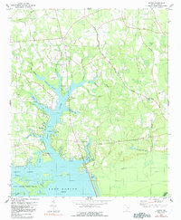
1980 Map of Jordan
USGS Topo · Published 1991About this map
The expansive waters of Lake Marion dominate this coastal plain landscape, defining a shoreline characterized by intricate inlets like Tranquility Cove and the broad Wyboo Swamp. Near the community of Jordan, the map reveals a rural social fabric anchored by numerous houses of worship, including Union Ch, Jordan Ch, and Cypress Ch. The transition from water to land is marked by an extensive network of tributaries such as White Oak Creek and Buckhead Branch, which drain into the reservoir. A historical transportation footprint is visible in the Old RR Grade running through the eastern forests. Farther south, near the edge of the Santee National Wildlife Refuge, recreational and utility infrastructure appears through features like the Boat Ramp and Camp Shelor, while the Clarendon County Airport and its Landing Strip provide modern connectivity to this lowland region.
Find a feature on this map
53 named features on this map. Tap any name to fly to it.
Don’t see what you’re looking for? This feature index may not catch every label — zoom into the map to look around manually.
Map Details
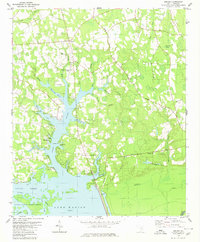
Editions of this 1980 Jordan Map
2 editions found
Other maps of this area

1920 · Eutawville
USGS Topo · 1:48,000

1920 · Chicora
USGS Topo · 1:48,000

1920 · Manning
USGS Topo · 1:48,000

1921 · Chicora
USGS Topo · 1:62,500

1921 · Manning
USGS Topo · 1:62,500

1921 · Eutawville
USGS Topo · 1:62,500

1943 · Chicora
USGS Topo · 1:62,500

1943 · Eutawville
USGS Topo · 1:62,500

1944 · Manning
USGS Topo · 1:62,500

1954 · Augusta
USGS Topo · 1:250,000