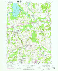
1978 Map of Jordan
USGS Topo · Published 1979About this map
The Seneca River and the legacy of the Erie Canal dominate this landscape during the late 1970s, where water-powered industry once thrived. The village of Jordan serves as a central hub, flanked by the steep rise of Pump Hill and the broad wetlands of McGraw Swamp. To the south, the settlement of Elbridge sits near the winding course of Skaneateles Creek, while the dual identity of Skaneateles Junction (Hart Lot PO) reflects the importance of the rail connection via Conrail. Local heritage is preserved in numerous burial grounds, including Maple Grove Cem and Mount Pleasant Cem, while landmarks like Science Hill and Ashbys Pinnacle provide topographic context to the agricultural and transit corridors of the Elbridge and Van Buren townships. The presence of a Fish Hatchery and several gravel pits indicates a landscape continuing to balance its natural resources with local industry.
Find a feature on this map
109 named features on this map. Tap any name to fly to it.
Don’t see what you’re looking for? This feature index may not catch every label — zoom into the map to look around manually.
Map Details
Editions of this 1978 Jordan Map
2 editions found
Other maps of this area

1899 · Auburn
USGS Topo · 1:62,500

1899 · Skaneateles
USGS Topo · 1:62,500

1900 · Baldwinsville
USGS Topo · 1:62,500

1902 · Skaneateles
USGS Topo · 1:62,500

1902 · Weedsport
USGS Topo · 1:62,500

1902 · Auburn
USGS Topo · 1:62,500

1943 · Jordan
USGS Topo · 1:31,680

1943 · Lysander
USGS Topo · 1:31,680

1943 · Cato
USGS Topo · 1:31,680

1943 · Weedsport
USGS Topo · 1:31,680