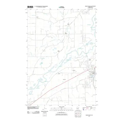
2010 Map of Jordan West
USGS Topo · Published 2010About this map
The Minnesota River carves a broad valley through this landscape, defining the boundaries of agricultural land and early settlements. On the eastern edge, Jordan serves as a significant hub, anchored by the Jordan Post Office and the Scott County Fairgrounds. The town's historical roots are evident in the proximity of Spirit Hill Cemetery and the engineering of the Sand Creek Dam on the Sand Creek Reservoir. To the west, the rural character of the area is preserved in the small community of East Union and the scattered locations of pioneer-era burial grounds like the Swedish Lutheran Cemetery, Swedish Methodist Cemetery, and Augustana Cemetery. The presence of School Number 25 and the Stocker Landing Field highlights the transition between early 20th-century educational infrastructure and modern private aviation. This map captures a landscape of numerous glacial lakes and ponds, including Ahlswede Lake and Johnson Lake, which have historically influenced local road placement and land use.
Find a feature on this map
67 named features on this map. Tap any name to fly to it.
Don’t see what you’re looking for? This feature index may not catch every label — zoom into the map to look around manually.
Map Details
Editions of this 2010 Jordan West Map
This is the sole edition of this map. No revisions or reprints were ever made.
Other maps of this area

1905 · Minnetonka
USGS Topo · 1:62,500

1907 · Minnetonka
USGS Topo · 1:62,500

1953 · Saint Paul
USGS Topo · 1:250,000

1957 · Belle Plaine
USGS Topo · 1:62,500

1957 · Waconia
USGS Topo · 1:62,500

1957 · New Prague
USGS Topo · 1:62,500

1958 · Victoria
USGS Topo · 1:24,000

1958 · Lake Minnetonka
USGS Topo · 1:62,500
1958 · Shakopee
USGS Topo · 1:24,000

1959 · Saint Paul
USGS Topo · 1:250,000