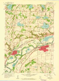
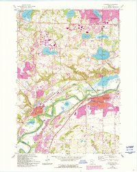
1958 Map of Shakopee
USGS Topo · Published 1959About this map
The Minnesota River valley serves as the central artery for this late-1950s landscape, where the growing settlements of Shakopee and Chaska face each other across the water. The river's influence is clear in the complex network of backwaters and floodplain lakes like Chaska Lake and Gifford Lake, protected by a Levee system. Industry and religion are deeply rooted here, evidenced by the numerous gravel pits dotting the bluffs and prominent institutions such as Assumption Seminary and the parochial St Marks Sch.
Find a feature on this map
54 named features on this map. Tap any name to fly to it.
Don’t see what you’re looking for? This feature index may not catch every label — zoom into the map to look around manually.
Map Details
Editions of this 1958 Shakopee Map
5 editions found
Other maps of this area

1896 · Minneapolis
USGS Topo · 1:62,500

1901 · Minneapolis
USGS Topo · 1:62,500

1905 · Minnetonka
USGS Topo · 1:62,500

1907 · Minnetonka
USGS Topo · 1:62,500

1953 · Saint Paul
USGS Topo · 1:250,000

1954 · Hopkins
USGS Topo · 1:24,000

1954 · Eden Prairie
USGS Topo · 1:24,000

1954 · Minneapolis
USGS Topo · 1:62,500

1957 · Prior Lake
USGS Topo · 1:62,500

1957 · New Prague
USGS Topo · 1:62,500