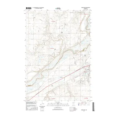
2016 Map of Jordan West
USGS Topo · Published 2016About this map
The Minnesota River corridor and its surrounding wetlands define this landscape south of East Union. The terrain is characterized by the expansive Louisville Swamp and the turbulent Carver Rapids, reflecting a complex hydrology that includes a dense network of lakes such as Scott Lake, Kelly Lake, and Johnson Lake. The Union Pacific RR follows the river's path, serving as a primary transit artery through the valley toward the settlement of Jordan.
Find a feature on this map
104 named features on this map. Tap any name to fly to it.
Don’t see what you’re looking for? This feature index may not catch every label — zoom into the map to look around manually.
Map Details
Editions of this 2016 Jordan West Map
This is the sole edition of this map. No revisions or reprints were ever made.
Other maps of this area

1905 · Minnetonka
USGS Topo · 1:62,500

1907 · Minnetonka
USGS Topo · 1:62,500

1953 · Saint Paul
USGS Topo · 1:250,000

1957 · Belle Plaine
USGS Topo · 1:62,500

1957 · Waconia
USGS Topo · 1:62,500

1957 · New Prague
USGS Topo · 1:62,500

1958 · Victoria
USGS Topo · 1:24,000

1958 · Lake Minnetonka
USGS Topo · 1:62,500
1958 · Shakopee
USGS Topo · 1:24,000

1959 · Saint Paul
USGS Topo · 1:250,000