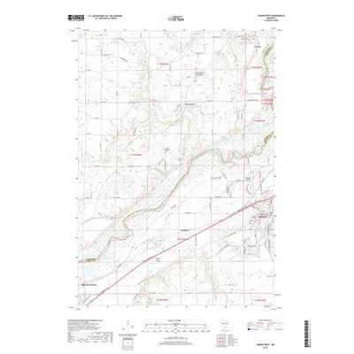
2019 Map of Jordan West
USGS Topo · Published 2019About this map
The Minnesota River corridor south of Carver defines this landscape, where the river's wide floodplains and winding bends separate the uplands of Carver and Scott counties. Settlement patterns reflect a deep history of Scandinavian heritage, evidenced by the Swedish Lutheran Or East Union Lutheran Cem and Swedish Methodist Cem. The small village of East Union sits atop the northern bluffs, while the community of Lawrence occupies a position near the river's southern banks.
Find a feature on this map
113 named features on this map. Tap any name to fly to it.
Don’t see what you’re looking for? This feature index may not catch every label — zoom into the map to look around manually.
Map Details
Editions of this 2019 Jordan West Map
This is the sole edition of this map. No revisions or reprints were ever made.
Other maps of this area

1905 · Minnetonka
USGS Topo · 1:62,500

1907 · Minnetonka
USGS Topo · 1:62,500

1953 · Saint Paul
USGS Topo · 1:250,000

1957 · Belle Plaine
USGS Topo · 1:62,500

1957 · Waconia
USGS Topo · 1:62,500

1957 · New Prague
USGS Topo · 1:62,500

1958 · Victoria
USGS Topo · 1:24,000

1958 · Lake Minnetonka
USGS Topo · 1:62,500
1958 · Shakopee
USGS Topo · 1:24,000

1959 · Saint Paul
USGS Topo · 1:250,000