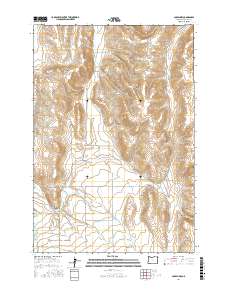
2017 Map of Joseph NW
USGS Topo · Published 2017About this map
Arkansas Hollow and Rocky Hollow define the undulating landscape of Wallowa County, where intricate water management systems have supported local agriculture for generations. The region is marked by an extensive network of irrigation features including Farmers Ditch, Granger Ditch, and the Wrenn Dobbin Ditch, which redirect water from natural courses like Prairie Cr and the Wallowa River. These man-made channels illustrate a legacy of land use designed to sustain the valley's productivity. In the eastern portion of the quadrangle, the terrain breaks into steep drainages such as Pine Tree Gulch and OK Gulch, while a web of named roads like Crow Creek Rd and Elk Mountain Rd provides access to the high plateaus and ranch lands that characterize this corner of Oregon.
Find a feature on this map
28 named features on this map. Tap any name to fly to it.
Don’t see what you’re looking for? This feature index may not catch every label — zoom into the map to look around manually.
Map Details
Editions of this 2017 Joseph NW Map
This is the sole edition of this map. No revisions or reprints were ever made.
Other maps of this area

1955 · Grangeville
USGS Topo · 1:250,000

1957 · Enterprise
USGS Topo · 1:62,500

1957 · Joseph
USGS Topo · 1:62,500

1957 · Sled Springs
USGS Topo · 1:62,500

1957 · Elk Mountain
USGS Topo · 1:62,500

1959 · Grangeville
USGS Topo · 1:250,000

1982 · Wallowa
USGS Topo · 1:100,000

1986 · Enterprise
USGS Topo · 1:100,000

1990 · Chief Joseph Mtn
USGS Topo · 1:24,000
1990 · Joseph
USGS Topo · 1:24,000