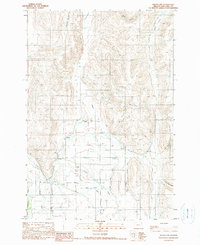
1990 Map of Joseph NW
USGS Topo · Published 1990About this map
Prairie Creek and the Wallowa River converge in the southwest corner of this landscape, where the water management of the late 20th century is clearly visible through an extensive network of irrigation infrastructure. The Farmers Ditch winds through the eastern portion of the quadrangle, serving the agricultural needs of the valley. Small named settlements like Dobbins and Wrenn are situated along the lower elevations, while the north and east are defined by deep drainage patterns including Arkansas Hollow, Baker Canyon, and Pine Tree Gulch.
Find a feature on this map
15 named features on this map. Tap any name to fly to it.
Don’t see what you’re looking for? This feature index may not catch every label — zoom into the map to look around manually.
Map Details
Editions of this 1990 Joseph NW Map
This is the sole edition of this map. No revisions or reprints were ever made.
Other maps of this area

1955 · Grangeville
USGS Topo · 1:250,000

1957 · Enterprise
USGS Topo · 1:62,500

1957 · Joseph
USGS Topo · 1:62,500

1957 · Sled Springs
USGS Topo · 1:62,500

1957 · Elk Mountain
USGS Topo · 1:62,500

1959 · Grangeville
USGS Topo · 1:250,000

1982 · Wallowa
USGS Topo · 1:100,000

1986 · Enterprise
USGS Topo · 1:100,000

1990 · Chief Joseph Mtn
USGS Topo · 1:24,000
1990 · Joseph
USGS Topo · 1:24,000