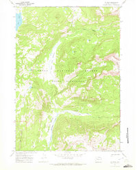
1965 Map of Joy Peak
USGS Topo · Published 1972About this map
Teton Wilderness and the Teton National Forest dominate this 1965 survey, depicting a high mountain landscape defined by deep valleys and prominent peaks. The hydraulic network is led by the North Fork Buffalo Fork and the Soda Fork Buffalo Fork, which converge near extensive alpine clearings like North Fork Meadows and Soda Fork Meadows. These meadows likely served as critical transit points and grazing areas for pack teams moving through the high country.
Find a feature on this map
21 named features on this map. Tap any name to fly to it.
Don’t see what you’re looking for? This feature index may not catch every label — zoom into the map to look around manually.
Map Details
Editions of this 1965 Joy Peak Map
2 editions found
Other maps of this area

1885 · Lake
USGS Topo · 1:125,000

1895 · Lake
USGS Topo · 1:125,000

1896 · Lake
USGS Topo · 1:125,000

1901 · Lake
USGS Topo · 1:125,000

1902 · Mt Leidy
USGS Topo · 1:125,000

1906 · Lake
USGS Topo · 1:125,000

1911 · Lake
USGS Topo · 1:125,000

1955 · Ashton
USGS Topo · 1:250,000

1955 · Driggs
USGS Topo · 1:250,000

1958 · Driggs
USGS Topo · 1:250,000