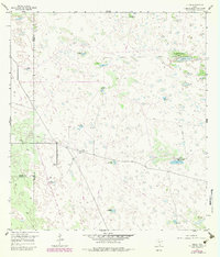
1956 Map of Julian
USGS Topo · Published 1983About this map
The arid plains of South Texas meet at the intersection of Brooks, Hidalgo, and Kenedy counties, a landscape defined by ranching infrastructure and mineral extraction. Water is the primary driver of settlement here, with numerous named water sources such as the Alazan Artesian Well, Caesar Artesian Well, and Rich Artesian Well dotting the terrain. These artesian wells, along with family-named landmarks like Alto Bonito Windmill and Tio Hilario Windmill, highlight the necessity of reliable groundwater in this remote stretch of the Brush Country.
Find a feature on this map
21 named features on this map. Tap any name to fly to it.
Don’t see what you’re looking for? This feature index may not catch every label — zoom into the map to look around manually.
Map Details
Editions of this 1956 Julian Map
2 editions found
Other maps of this area

1922 · La Sal Vieja
USGS Topo · 1:62,500

1923 · Armstrong
USGS Topo · 1:62,500

1939 · Linn
USGS Topo · 1:62,500

1949 · Mc Allen
USGS Topo · 1:250,000

1953 · Brownsville
USGS Topo · 1:250,000

1954 · McAllen
USGS Topo · 1:250,000

1956 · Pita Camp
USGS Topo · 1:24,000
1956 · Armstrong
USGS Topo · 1:24,000

1956 · Julian
USGS Topo · 1:24,000

1956 · Rudolph
USGS Topo · 1:24,000