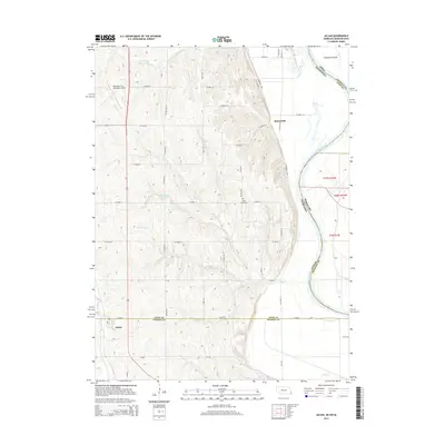
2014 Map of Julian
USGS Topo · Published 2014About this map
The village of Julian sits at the southern edge of this survey near the Otoe Co Nemaha Co boundary, serving as a quiet focal point in a landscape defined by organized agriculture and dendritic creek systems. To the northeast, the Missouri River carves a winding path that establishes the state line between Nebraska, Iowa, and Missouri, creating the distinct landform of Schemmel Island. The terrain is deeply etched by the various branches of Camp Cr, including N Br Camp Cr and S Br Camp Cr, which feed into the Buffalo City Reservoir. Local history is anchored by the Camp Creek Cem and the settlement of Minersville, while modern transportation is represented by 75 and the Nebraska City Municipal Airport. The presence of the Steamboat Trce along the river bluffs highlights the transition from historical river-based commerce to contemporary recreational use of the valley corridor.
Find a feature on this map
46 named features on this map. Tap any name to fly to it.
Don’t see what you’re looking for? This feature index may not catch every label — zoom into the map to look around manually.
Map Details
Editions of this 2014 Julian Map
This is the sole edition of this map. No revisions or reprints were ever made.
Other maps of this area

1907 · Nebraska City
USGS Topo · 1:62,500

1915 · Nemaha
USGS Topo · 1:62,500

1915 · Howe
USGS Topo · 1:62,500

1939 · Hamburg
USGS Topo · 1:62,500

1939 · Nemaha
USGS Topo · 1:62,500

1941 · Hamburg
USGS Topo · 1:62,500

1949 · Nemaha
USGS Topo · 1:62,500

1955 · Nebraska City
USGS Topo · 1:250,000

1957 · Nebraska City
USGS Topo · 1:250,000

1958 · Nebraska City
USGS Topo · 1:250,000