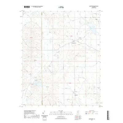
2020 Map of Jumpertown
USGS Topo · Published 2020About this map
The Tippah Hills and the winding course of the Hatchie River define the rural character of this Prentiss County landscape. Centered on the settlement of Jumpertown, the area is characterized by a network of small streams like Pollus Creek and Little Wolf Cr that feed into larger local basins. Cultural and genealogical history is deeply rooted in several community landmarks, including Morton Chapel Cem, Pauls Chapel Cem, and Pisgah Cem. The terrain transitions from the low-lying waters of Cox Lake and Lake Mohawk to the higher elevations of King Hollow. This modern survey documents the persistent boundary between Tippah and Prentiss counties, showing how historic rural roads still link these long-established communities and their associated family burial grounds.
Find a feature on this map
91 named features on this map. Tap any name to fly to it.
Don’t see what you’re looking for? This feature index may not catch every label — zoom into the map to look around manually.
Map Details
Editions of this 2020 Jumpertown Map
This is the sole edition of this map. No revisions or reprints were ever made.
Other maps of this area

1921 · Booneville
USGS Topo · 1:48,000

1922 · Booneville
USGS Topo · 1:62,500

1950 · Corinth
USGS Topo · 1:62,500

1951 · Walnut
USGS Topo · 1:62,500

1955 · Ripley
USGS Topo · 1:62,500

1956 · Tupelo
USGS Topo · 1:250,000

1958 · Tupelo
USGS Topo · 1:250,000

1972 · Jumpertown
USGS Topo · 1:24,000
1973 · Wheeler
USGS Topo · 1:24,000
1973 · Baldwyn
USGS Topo · 1:24,000