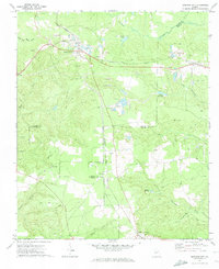
1971 Map of Junction City
USGS Topo · Published 1974About this map
Junction City serves as the focal point of this rural Georgia landscape, positioned at the intersection of the Seaboard Coast Line and the Central of Georgia railroads. The town's industrial character is defined by a heavy concentration of sandpits, reflecting the area's geology and its reliance on rail transport for mineral extraction. To the south and east, the terrain transitions into a more traditional agricultural and water-powered economy, evidenced by the presence of Parks Millpond and Watson Millpond.
Find a feature on this map
30 named features on this map. Tap any name to fly to it.
Don’t see what you’re looking for? This feature index may not catch every label — zoom into the map to look around manually.
Map Details
Editions of this 1971 Junction City Map
2 editions found
Other maps of this area

1907 · Talbotton
USGS Topo · 1:125,000

1950 · Talbotton
USGS Topo · 1:24,000

1950 · Geneva
USGS Topo · 1:24,000

1950 · Buena Vista NE
USGS Topo · 1:24,000

1950 · Buena Vista
USGS Topo · 1:62,500

1950 · Talbotton
USGS Topo · 1:62,500

1955 · Talbotton
USGS Topo · 1:24,000

1955 · Buena Vista NE
USGS Topo · 1:24,000
1955 · Geneva
USGS Topo · 1:24,000
1955 · Talbotton
USGS Topo · 1:62,500