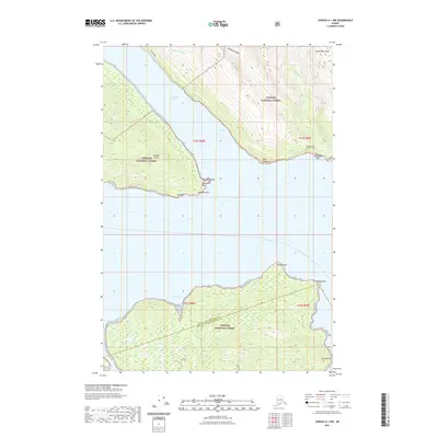
2021 Map of Juneau A-1 NW
USGS Topo · Published 2021About this map
Douglas Island and the Gastineau Channel dominate this southeastern Alaskan landscape, where the waters of Green Cove and the northern tip of Admiralty Island meet the mainland. The area is defined by sharp elevation changes, from the tidal Cherokee Flats and Point Salisbury up to the high-altitude South Rhine Peak. The Thane Road corridor provides limited coastal access on the mainland side, passing through the Tongass National Forest. Significant cultural and natural landmarks are noted, including the Kuteha Indian Burial Grounds on the eastern shore and the hydrological features of Grindstone Falls and Little Sheep Creek. This survey captures the boundary between the Juneau City and Borough and the Hoonah-Angoon Census Area, reflecting the complex administrative and natural geography of the Panhandle.
Find a feature on this map
27 named features on this map. Tap any name to fly to it.
Don’t see what you’re looking for? This feature index may not catch every label — zoom into the map to look around manually.
Map Details
Editions of this 2021 Juneau A-1 NW Map
This is the sole edition of this map. No revisions or reprints were ever made.
Other maps of this area

1947 · Juneau B-2
USGS Topo · 1:63,360

1948 · Juneau B-1
USGS Topo · 1:63,360

1949 · Juneau B-2
USGS Topo · 1:62,500

1951 · Juneau
USGS Topo · 1:250,000

1951 · Juneau A-2
USGS Topo · 1:63,360

1951 · Juneau A-1
USGS Topo · 1:63,360

1952 · Juneau B-1
USGS Topo · 1:63,360

1954 · Juneau A-1
USGS Topo · 1:63,360

1962 · Juneau B-2
USGS Topo · 1:63,360

1962 · Juneau
USGS Topo · 1:250,000