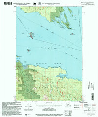
1995 Map of Juneau A-4
USGS Topo · Published 1999About this map
Chichagof Island and the expansive waters of Icy Strait characterize this northern Alexander Archipelago landscape during the mid-1990s. The map highlights a coastal environment defined by maritime navigation and timber infrastructure, featuring a Log Transfer Facility at Whitestone Harbor and a state-operated Boat Dock within Swanson Harbor. Navigational aids are prominent across the maritime corridor, including the Lighthouse Reserve near The Sisters and a Vortac Station used for regional aviation. Evidence of earlier occupation appears in the form of Cabin Ruins and various isolated Cabins situated along the shoreline of the Tongass National Forest. Inland, the terrain rises sharply toward Elephant Mountain, while drainage systems like Suntaheen Creek and Spasski Creek flow toward the surrounding channels of Lynn Canal.
Find a feature on this map
41 named features on this map. Tap any name to fly to it.
Don’t see what you’re looking for? This feature index may not catch every label — zoom into the map to look around manually.
Map Details
Editions of this 1995 Juneau A-4 Map
This is the sole edition of this map. No revisions or reprints were ever made.
Other maps of this area

1947 · Juneau B-3
USGS Topo · 1:63,360

1948 · Juneau B-4
USGS Topo · 1:63,360

1948 · Juneau A-3
USGS Topo · 1:63,360

1948 · Juneau A-4
USGS Topo · 1:63,360

1948 · Juneau B-5
USGS Topo · 1:63,360

1948 · Sitka D-5
USGS Topo · 1:63,360

1948 · Sitka D-3
USGS Topo · 1:63,360

1948 · Sitka D-4
USGS Topo · 1:63,360

1949 · Juneau B-3
USGS Topo · 1:62,500

1949 · Juneau B-4
USGS Topo · 1:63,360