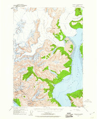
1952 Map of Juneau B-1
USGS Topo · Published 1960About this map
Taku Glacier and the massive ice fields of the Norris Glacier dominate this mid-century view of the Alaskan wilderness east of Juneau. The landscape is defined by the dramatic meeting of ice and sea at Taku Inlet, where glacial tongues descend from the Tongass National Forest toward the water. Industrial and mining activity is concentrated along the Gastineau Channel near Thane, where a network of Mines and an Aerial Tram indicate the difficult extraction efforts of the era. Further inland, the presence of Portal Camp, a Pipe Line, and a Power Plant near Annex Lakes and Annex Creek highlights the specialized infrastructure built to harness water power and support remote operations. From the high peaks like Olds Mtn and Hawthorne Pk to the sheltered waters of Sunny Cove, the map documents a territory where industrial progress was inextricably linked to extreme geography.
Find a feature on this map
32 named features on this map. Tap any name to fly to it.
Don’t see what you’re looking for? This feature index may not catch every label — zoom into the map to look around manually.
Map Details
Editions of this 1952 Juneau B-1 Map
3 editions found
Other maps of this area

1947 · Juneau B-2
USGS Topo · 1:63,360

1948 · Juneau B-1
USGS Topo · 1:63,360

1949 · Juneau B-2
USGS Topo · 1:62,500

1951 · Juneau
USGS Topo · 1:250,000

1951 · Taku River B-6
USGS Topo · 1:63,360

1951 · Taku River A-6
USGS Topo · 1:63,360

1951 · Juneau A-2
USGS Topo · 1:63,360

1951 · Juneau A-1
USGS Topo · 1:63,360

1952 · Juneau B-1
USGS Topo · 1:63,360

1953 · Taku River
USGS Topo · 1:250,000