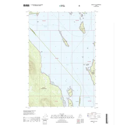
2017 Map of Juneau B-3 SE
USGS Topo · Published 2017About this map
Stephens Passage dominates this coastal survey, serving as the central waterway between the mainland and several large islands within the Tongass National Forest. The map illustrates the complex maritime geography near Juneau, highlighting prominent landmasses such as Shelter Island, Coghlan Island, and Portland Island. Coastal navigation points are well-defined, including Adams Anchorage on the southern tip of Shelter Island and Point Louisa near the mouth of Auke Bay. On the mainland, the terrain rises sharply toward Lone Mtn, while further south, the Gulf of Alaska begins to open past Douglas Island. The boundary line between Juneau Borough and Hoonah-Angoon Census Area cuts diagonally across the open water, dividing these remote reaches of the Alexander Archipelago. Small islands and navigational hazards like Strauss Rock and Horse Shoal provide critical detail for maritime historians and those studying the shoreline of southeast Alaska.
Find a feature on this map
35 named features on this map. Tap any name to fly to it.
Don’t see what you’re looking for? This feature index may not catch every label — zoom into the map to look around manually.
Map Details
Editions of this 2017 Juneau B-3 SE Map
This is the sole edition of this map. No revisions or reprints were ever made.
Other maps of this area

1947 · Juneau B-3
USGS Topo · 1:63,360

1947 · Juneau B-2
USGS Topo · 1:63,360

1948 · Juneau A-3
USGS Topo · 1:63,360

1949 · Juneau B-3
USGS Topo · 1:62,500

1949 · Juneau B-2
USGS Topo · 1:62,500

1950 · Juneau A-3
USGS Topo · 1:63,360

1951 · Juneau
USGS Topo · 1:250,000

1951 · Juneau A-2
USGS Topo · 1:63,360

1962 · Juneau B-2
USGS Topo · 1:63,360

1962 · Juneau B-3
USGS Topo · 1:63,360