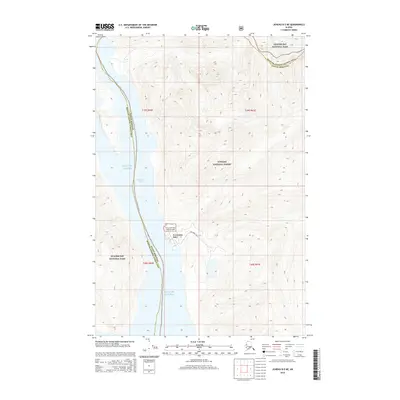
2015 Map of Juneau B-5 NE
USGS Topo · Published 2015About this map
Excursion Inlet serves as a critical maritime corridor in this coastal Alaskan landscape, where the waters of the Gulf of Alaska reach deep into the mountainous terrain. The settlement of Excursion Inlet is a key focal point, supported by the Excursion Inlet Seaplane Base, which provides essential air connectivity for this isolated community. This 2015 survey illustrates the complex jurisdictional boundaries of the region, specifically the Haines Borough Hoonah-Angoon Census Area line. Large-scale federal land management is evident, as the map captures the meeting point of Glacier Bay National Park and the Tongass National Forest. The transition from the protected wilderness of the national park to the managed forest lands defines the local geography, highlighting the region's reliance on both maritime and aviation infrastructure for transport and industry.
Find a feature on this map
11 named features on this map. Tap any name to fly to it.
Don’t see what you’re looking for? This feature index may not catch every label — zoom into the map to look around manually.
Map Details
Editions of this 2015 Juneau B-5 NE Map
This is the sole edition of this map. No revisions or reprints were ever made.
Other maps of this area

1948 · Juneau C-5
USGS Topo · 1:63,360

1948 · Juneau B-4
USGS Topo · 1:63,360

1948 · Juneau C-4
USGS Topo · 1:63,360

1948 · Juneau B-5
USGS Topo · 1:63,360

1949 · Juneau C-4
USGS Topo · 1:63,360

1949 · Juneau B-4
USGS Topo · 1:63,360

1950 · Juneau B-5
USGS Topo · 1:63,360

1951 · Juneau
USGS Topo · 1:250,000

1962 · Juneau
USGS Topo · 1:250,000
1996 · Juneau B-4
USGS Topo · 1:63,360