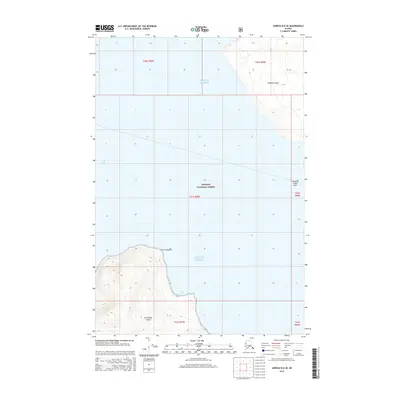
2015 Map of Juneau B-6 SE
USGS Topo · Published 2015About this map
Chichagof Island and the northern reaches of the Tongass National Forest dominate this coastal survey. The terrain is defined by the deep waters of Icy Strait and the open Gulf of Alaska, which separate the rugged northern shore of Chichagof from the neighboring Pleasant Island. This maritime landscape includes notable navigational landmarks such as Point Adolphus and the submerged hazards of Pleasant Island Reef. Along the coastline, Pinta Cove provides a break in the shoreline of Chichagof Island, offering a glimpse into the topographical layout of the Unorganized Borough in 2015. The map reflects a region where the vast forest and intricate waterways serve as the primary geographical features, with no modern road infrastructure present on these landmasses.
Find a feature on this map
14 named features on this map. Tap any name to fly to it.
Don’t see what you’re looking for? This feature index may not catch every label — zoom into the map to look around manually.
Map Details
Editions of this 2015 Juneau B-6 SE Map
This is the sole edition of this map. No revisions or reprints were ever made.
Other maps of this area

1948 · Juneau B-6
USGS Topo · 1:63,360

1948 · Juneau B-5
USGS Topo · 1:63,360

1950 · Juneau B-5
USGS Topo · 1:63,360

1951 · Juneau
USGS Topo · 1:250,000

1951 · Juneau A-6
USGS Topo · 1:63,360

1951 · Juneau A-5
USGS Topo · 1:63,360

1962 · Juneau
USGS Topo · 1:250,000
1994 · Juneau A-5
USGS Topo · 1:63,360
2000 · Juneau A-6
USGS Topo · 1:63,360
2015 · Juneau B-5 NW
USGS Topo · 1:25,000