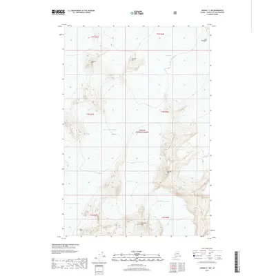
2017 Map of Juneau C-1 SW
USGS Topo · Published 2017About this map
Taku Glacier dominates the upper reaches of this landscape within the Tongass National Forest, illustrating the massive ice fields that define the Coast Mountains. The terrain is characterized by high-elevation peaks and interconnected glacial systems, including the Norris Glacier and its North Branch Norris Glacier in the southern portion of the sheet. Between these frozen expanses, landmarks such as Juncture Peak and Shoehorn Mtn emerge from the ice, while Echo Pass provides a notable transit point in the southwest corner near Guardian Mtn. This survey provides a precise view of the mid-2010s glacial extent and the surrounding peaks like Slanting Peak, offering a baseline for understanding the physical geography of this remote Alaskan wilderness.
Find a feature on this map
17 named features on this map. Tap any name to fly to it.
Don’t see what you’re looking for? This feature index may not catch every label — zoom into the map to look around manually.
Map Details
Editions of this 2017 Juneau C-1 SW Map
This is the sole edition of this map. No revisions or reprints were ever made.
Other maps of this area

1947 · Juneau B-2
USGS Topo · 1:63,360

1948 · Juneau B-1
USGS Topo · 1:63,360

1949 · Juneau B-2
USGS Topo · 1:62,500

1951 · Juneau
USGS Topo · 1:250,000

1952 · Juneau B-1
USGS Topo · 1:63,360

1960 · Juneau C-2
USGS Topo · 1:63,360

1960 · Juneau C-1
USGS Topo · 1:63,360

1962 · Juneau B-2
USGS Topo · 1:63,360

1962 · Juneau
USGS Topo · 1:250,000
1997 · Juneau B-1
USGS Topo · 1:63,360