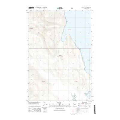
2015 Map of Juneau C-4 NW
USGS Topo · Published 2015About this map
Tongass National Forest encompasses the entirety of this coastal landscape, where the maritime influence of the Gulf of Alaska meets the steep topography of southeast Alaska. The shoreline is marked by prominent landforms such as Lance Point and Danger Point, which shelter the waters of William Henry Bay. This bay serves as the primary drainage for both William Henry Cr and the Beardslee River, creating a complex estuarine environment at the mountain's base. Further south, the protected inlet of Boat Harbor provides a natural anchorage along an otherwise exposed coastline. The map illustrates the 2015 configuration of these tidal reaches and river mouths, documenting the intersection of glacial-carved terrain and the Pacific coast within the United States' largest national forest.
Find a feature on this map
12 named features on this map. Tap any name to fly to it.
Don’t see what you’re looking for? This feature index may not catch every label — zoom into the map to look around manually.
Map Details
Editions of this 2015 Juneau C-4 NW Map
This is the sole edition of this map. No revisions or reprints were ever made.
Other maps of this area

1948 · Juneau C-5
USGS Topo · 1:63,360

1948 · Juneau C-4
USGS Topo · 1:63,360

1949 · Juneau D-5
USGS Topo · 1:63,360

1949 · Juneau D-4
USGS Topo · 1:63,360

1949 · Juneau C-4
USGS Topo · 1:63,360

1951 · Juneau
USGS Topo · 1:250,000

1951 · Juneau D-4
USGS Topo · 1:63,360

1962 · Juneau
USGS Topo · 1:250,000
1996 · Juneau C-4
USGS Topo · 1:63,360
1996 · Juneau D-5
USGS Topo · 1:63,360