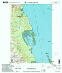
1996 Map of Juneau C-4
USGS Topo · Published 2000About this map
The waters of the Lynn Canal serve as the primary artery for travel in this maritime wilderness, where the Alaska Marine Highway provides the only connection between the Haines Borough and the City and Borough of Juneau. The landscape is dominated by the dense geography of the Tongass National Forest and the protected lands of the Endicott River Wilderness. Scattered coastal outposts, including a Radio Repeater at William Henry Bay and isolated cabins near Saint James Point, indicate the limited human footprint in an area primarily defined by navigational landmarks and natural harborages.
Find a feature on this map
31 named features on this map. Tap any name to fly to it.
Don’t see what you’re looking for? This feature index may not catch every label — zoom into the map to look around manually.
Map Details
Editions of this 1996 Juneau C-4 Map
This is the sole edition of this map. No revisions or reprints were ever made.
Other maps of this area

1947 · Juneau B-3
USGS Topo · 1:63,360

1948 · Juneau C-5
USGS Topo · 1:63,360

1948 · Juneau B-4
USGS Topo · 1:63,360

1948 · Juneau C-4
USGS Topo · 1:63,360

1948 · Juneau B-5
USGS Topo · 1:63,360

1948 · Juneau D-3
USGS Topo · 1:63,360

1949 · Juneau B-3
USGS Topo · 1:62,500

1949 · Juneau D-5
USGS Topo · 1:63,360

1949 · Juneau D-4
USGS Topo · 1:63,360

1949 · Juneau C-4
USGS Topo · 1:63,360