
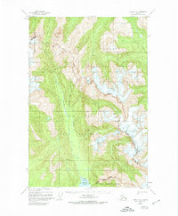
1948 Map of Juneau C-5
USGS Topo · Published 1956About this map
The Chilkat Range forms a dramatic topographic divide on this mid-century survey, separating the lands of the Tongass National Forest from the protected wilderness of Glacier Bay National Monument. This boundary is marked by high alpine peaks and significant ice fields, including the geodetic marker at VABM 5012 Stell. The southeastern corner of the map reveals the upper reaches of Excursion Inlet, where the marine environment meets the land at a prominent Tidal Flat. Unlike maps of developed regions, this sheet is defined by natural markers and survey points rather than settlements, documenting the transition between the national forest and the monument's preserved glacial landscape before later administrative expansions or changes to the coastline.
Find a feature on this map
10 named features on this map. Tap any name to fly to it.
Don’t see what you’re looking for? This feature index may not catch every label — zoom into the map to look around manually.
Map Details
Editions of this 1948 Juneau C-5 Map
2 editions found
Other maps of this area

1948 · Juneau B-4
USGS Topo · 1:63,360

1948 · Juneau B-6
USGS Topo · 1:63,360

1948 · Juneau C-4
USGS Topo · 1:63,360

1948 · Juneau C-6
USGS Topo · 1:63,360

1948 · Juneau B-5
USGS Topo · 1:63,360

1949 · Juneau D-6
USGS Topo · 1:63,360

1949 · Juneau D-5
USGS Topo · 1:63,360

1949 · Juneau D-4
USGS Topo · 1:63,360

1949 · Juneau C-4
USGS Topo · 1:63,360

1949 · Juneau B-4
USGS Topo · 1:63,360