
1948 Map of Juneau C-5
USGS Topo · Published 1974About this map
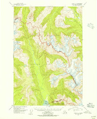
The Chilkat Range dominates this late-1940s landscape, serving as a natural divider between the protected wilderness of Glacier Bay National Monument and the Tongass National Forest. This survey captures the transition of the Alaskan shoreline, where the Excursion River flows southward into the waters of Excursion Inlet. The presence of a significant Tidal Flat at the head of the inlet indicates a dynamic intertidal environment with an average tide range of thirteen feet. Human presence is minimal and concentrated in specific shelters, marked only by scattered Cabins and a few established Trails. The northern portion of the map identifies the administrative boundary for the Haines Borough, illustrating the jurisdictional reach into these high-altitude terrains where ice fields and ridges form a complex topography.
Find a feature on this map
13 named features on this map. Tap any name to fly to it.
Don’t see what you’re looking for? This feature index may not catch every label — zoom into the map to look around manually.
Map Details
Editions of this 1948 Juneau C-5 Map
2 editions found
Historical Maps of Excursion Inlet Through Time
525 maps found

1943 Sumdum B-4
Hoonah-Angoon Borough, AK

1948 Juneau A-3
Hoonah-Angoon Borough, AK

1948 Juneau A-4
Hoonah-Angoon Borough, AK

1948 Juneau B-5
Hoonah-Angoon Borough, AK

1948 Juneau B-6
Hoonah-Angoon Borough, AK
1948 Juneau C-5
Hoonah-Angoon Borough, AK

1948 Juneau C-6
Hoonah-Angoon Borough, AK

1948 Mount Fairweather A-1
Hoonah-Angoon Borough, AK

1948 Mount Fairweather A-2
Hoonah-Angoon Borough, AK

1948 Mount Fairweather B-1
Hoonah-Angoon Borough, AK

1948 Mount Fairweather B-2
Hoonah-Angoon Borough, AK

1948 Mount Fairweather C-1
Hoonah-Angoon Borough, AK

1948 Mount Fairweather C-2
Hoonah-Angoon Borough, AK

1948 Mt. Fairweather D-1
Hoonah-Angoon Borough, AK

1948 Mt. Fairweather D-2
Hoonah-Angoon Borough, AK

1948 Port Alexander D-1
Hoonah-Angoon Borough, AK

1948 Sitka A-1
Hoonah-Angoon Borough, AK

1948 Sitka A-2
Hoonah-Angoon Borough, AK

1948 Sitka B-1
Hoonah-Angoon Borough, AK

1948 Sitka B-2
Hoonah-Angoon Borough, AK

1948 Sitka C-1
Hoonah-Angoon Borough, AK

1948 Sitka C-2
Hoonah-Angoon Borough, AK

1948 Sitka D-1
Hoonah-Angoon Borough, AK

1948 Sitka D-2
Hoonah-Angoon Borough, AK

1948 Sitka D-3
Hoonah-Angoon Borough, AK

1948 Sitka D-4
Hoonah-Angoon Borough, AK

1948 Sitka D-5
Hoonah-Angoon Borough, AK

1948 Sitka D-8
Hoonah-Angoon Borough, AK

1948 Sumdum A-4
Hoonah-Angoon Borough, AK

1948 Sumdum A-5
Hoonah-Angoon Borough, AK

1948 Sumdum A-6
Hoonah-Angoon Borough, AK

1948 Sumdum B-4
Hoonah-Angoon Borough, AK

1948 Sumdum B-5
Hoonah-Angoon Borough, AK

1948 Sumdum B-6
Hoonah-Angoon Borough, AK

1948 Sumdum C-5
Hoonah-Angoon Borough, AK

1948 Sumdum C-6
Hoonah-Angoon Borough, AK

1948 Sumdum D-5
Hoonah-Angoon Borough, AK

1949 Juneau D-6
Hoonah-Angoon Borough, AK

1949 Mount Fairweather C-1
Hoonah-Angoon Borough, AK

1950 Juneau A-3
Hoonah-Angoon Borough, AK

1950 Juneau B-5
Hoonah-Angoon Borough, AK

1950 Juneau C-6
Hoonah-Angoon Borough, AK

1950 Mount Fairweather C-2
Hoonah-Angoon Borough, AK

1950 Mount Fairweather D-2
Hoonah-Angoon Borough, AK

1950 Sitka D-8
Hoonah-Angoon Borough, AK

1951 Juneau A-5
Hoonah-Angoon Borough, AK

1951 Juneau A-6
Hoonah-Angoon Borough, AK

1951 Mt Fairweather
Hoonah-Angoon Borough, AK

1951 Port Alexander D-2
Hoonah-Angoon Borough, AK

1951 Sitka A-2
Hoonah-Angoon Borough, AK

1951 Sitka B-1
Hoonah-Angoon Borough, AK

1951 Sitka B-2
Hoonah-Angoon Borough, AK

1951 Sitka C-1
Hoonah-Angoon Borough, AK

1951 Sitka C-2
Hoonah-Angoon Borough, AK

1951 Sitka D-1
Hoonah-Angoon Borough, AK

1951 Sitka D-2
Hoonah-Angoon Borough, AK

1951 Sitka D-3
Hoonah-Angoon Borough, AK

1951 Sitka D-5
Hoonah-Angoon Borough, AK

1951 Sitka D-7
Hoonah-Angoon Borough, AK

1951 Sumdum A-4
Hoonah-Angoon Borough, AK

1951 Sumdum B-5
Hoonah-Angoon Borough, AK

1951 Sumdum C-5
Hoonah-Angoon Borough, AK

1951 Sumdum C-6
Hoonah-Angoon Borough, AK

1951 Taku River A-4
Hoonah-Angoon Borough, AK

1952 Sumdum
Hoonah-Angoon Borough, AK

1954 Mount Fairweather A-1
Hoonah-Angoon Borough, AK

1954 Mount Fairweather D-1
Hoonah-Angoon Borough, AK

1954 Skagway A-3
Hoonah-Angoon Borough, AK

1955 Sitka D-4
Hoonah-Angoon Borough, AK

1955 Sumdum D-5
Hoonah-Angoon Borough, AK

1960 Sumdum D-4
Hoonah-Angoon Borough, AK

1961 Mount Fairweather A-3
Hoonah-Angoon Borough, AK

1961 Mount Fairweather B-3
Hoonah-Angoon Borough, AK

1961 Mount Fairweather C-3
Hoonah-Angoon Borough, AK

1961 Mount Fairweather C-4
Hoonah-Angoon Borough, AK

1961 Mount Fairweather C-5
Hoonah-Angoon Borough, AK

1961 Mount Fairweather C-6
Hoonah-Angoon Borough, AK

1961 Mount Fairweather D-3
Hoonah-Angoon Borough, AK

1961 Mount Fairweather D-4
Hoonah-Angoon Borough, AK

1961 Mount Fairweather D-5
Hoonah-Angoon Borough, AK

1961 Mt Fairweather B-4
Hoonah-Angoon Borough, AK

1961 Mt Fairweather
Hoonah-Angoon Borough, AK

1961 Skagway A-4
Hoonah-Angoon Borough, AK

1961 Skagway A-5
Hoonah-Angoon Borough, AK

1961 Skagway A-6
Hoonah-Angoon Borough, AK

1961 Sumdum B-2
Hoonah-Angoon Borough, AK

1961 Sumdum B-3
Hoonah-Angoon Borough, AK

1961 Sumdum C-2
Hoonah-Angoon Borough, AK

1961 Sumdum C-3
Hoonah-Angoon Borough, AK

1961 Sumdum C-4
Hoonah-Angoon Borough, AK

1961 Sumdum D-3
Hoonah-Angoon Borough, AK

1961 Sumdum
Hoonah-Angoon Borough, AK

1986 Juneau B-3 SW
Hoonah-Angoon Borough, AK

1994 Juneau A-5
Hoonah-Angoon Borough, AK

1994 Sumdum A-6
Hoonah-Angoon Borough, AK

1994 Sumdum D-4
Hoonah-Angoon Borough, AK

1994 Sumdum D-5
Hoonah-Angoon Borough, AK

1995 Juneau A-4
Hoonah-Angoon Borough, AK

1995 Port Alexander D-2
Hoonah-Angoon Borough, AK

1995 Sitka D-8
Hoonah-Angoon Borough, AK

1996 Sumdum B-3
Hoonah-Angoon Borough, AK

1996 Sumdum B-4
Hoonah-Angoon Borough, AK

1996 Sumdum B-5
Hoonah-Angoon Borough, AK

1997 Juneau A-3
Hoonah-Angoon Borough, AK

1997 Port Alexander D-1
Hoonah-Angoon Borough, AK

1997 Sitka D-2
Hoonah-Angoon Borough, AK

1997 Sitka D-3
Hoonah-Angoon Borough, AK

1997 Sitka D-4
Hoonah-Angoon Borough, AK

1997 Sitka D-5
Hoonah-Angoon Borough, AK

1997 Sitka D-7
Hoonah-Angoon Borough, AK

2000 Juneau A-6
Hoonah-Angoon Borough, AK

2000 Sitka B-2
Hoonah-Angoon Borough, AK

2000 Sumdum B-2
Hoonah-Angoon Borough, AK

2000 Sumdum C-3
Hoonah-Angoon Borough, AK

2015 Juneau A-5 NE
Hoonah-Angoon Borough, AK

2015 Juneau A-5 NW
Hoonah-Angoon Borough, AK

2015 Juneau A-6 NE
Hoonah-Angoon Borough, AK

2015 Juneau A-6 NW
Hoonah-Angoon Borough, AK

2015 Juneau B-5 NW
Hoonah-Angoon Borough, AK

2015 Juneau B-5 SW
Hoonah-Angoon Borough, AK

2015 Juneau B-6 NE
Hoonah-Angoon Borough, AK

2015 Juneau B-6 SE
Hoonah-Angoon Borough, AK

2017 Juneau A-1 SE
Hoonah-Angoon Borough, AK

2017 Juneau A-1 SW
Hoonah-Angoon Borough, AK

2017 Juneau A-2 SE
Hoonah-Angoon Borough, AK

2017 Juneau A-2 SW
Hoonah-Angoon Borough, AK

2017 Juneau A-3 NE
Hoonah-Angoon Borough, AK

2017 Juneau A-3 NW
Hoonah-Angoon Borough, AK

2017 Juneau A-3 SE
Hoonah-Angoon Borough, AK

2017 Juneau A-3 SW
Hoonah-Angoon Borough, AK

2017 Juneau A-4 SE
Hoonah-Angoon Borough, AK

2017 Juneau A-4 SW
Hoonah-Angoon Borough, AK

2017 Juneau A-5 SE
Hoonah-Angoon Borough, AK

2017 Juneau A-5 SW
Hoonah-Angoon Borough, AK

2017 Juneau A-6 SE
Hoonah-Angoon Borough, AK

2017 Juneau A-6 SW
Hoonah-Angoon Borough, AK

2017 Juneau B-3 SW
Hoonah-Angoon Borough, AK

2017 Juneau B-6 NW
Hoonah-Angoon Borough, AK

2017 Juneau B-6 SW
Hoonah-Angoon Borough, AK

2017 Juneau C-5 NW
Hoonah-Angoon Borough, AK

2017 Juneau C-5 SE
Hoonah-Angoon Borough, AK

2017 Juneau C-5 SW
Hoonah-Angoon Borough, AK

2017 Juneau C-6 NE
Hoonah-Angoon Borough, AK

2017 Juneau C-6 NW
Hoonah-Angoon Borough, AK

2017 Juneau C-6 SE
Hoonah-Angoon Borough, AK

2017 Juneau C-6 SW
Hoonah-Angoon Borough, AK

2017 Juneau D-5 NW
Hoonah-Angoon Borough, AK

2017 Juneau D-6 NE
Hoonah-Angoon Borough, AK

2017 Juneau D-6 NW
Hoonah-Angoon Borough, AK

2017 Juneau D-6 SE
Hoonah-Angoon Borough, AK

2017 Juneau D-6 SW
Hoonah-Angoon Borough, AK

2017 Mount Fairweather A-1 NE
Hoonah-Angoon Borough, AK

2017 Mount Fairweather A-1 NW
Hoonah-Angoon Borough, AK

2017 Mount Fairweather A-1 SE
Hoonah-Angoon Borough, AK

2017 Mount Fairweather A-1 SW
Hoonah-Angoon Borough, AK

2017 Mount Fairweather A-2 NE
Hoonah-Angoon Borough, AK

2017 Mount Fairweather A-2 NW
Hoonah-Angoon Borough, AK

2017 Mount Fairweather A-2 SE
Hoonah-Angoon Borough, AK

2017 Mount Fairweather A-2 SW
Hoonah-Angoon Borough, AK

2017 Mount Fairweather A-3 NE
Hoonah-Angoon Borough, AK

2017 Mount Fairweather B-1 NE
Hoonah-Angoon Borough, AK

2017 Mount Fairweather B-1 NW
Hoonah-Angoon Borough, AK

2017 Mount Fairweather B-1 SE
Hoonah-Angoon Borough, AK

2017 Mount Fairweather B-1 SW
Hoonah-Angoon Borough, AK

2017 Mount Fairweather B-2 NE
Hoonah-Angoon Borough, AK

2017 Mount Fairweather B-2 NW
Hoonah-Angoon Borough, AK

2017 Mount Fairweather B-2 SE
Hoonah-Angoon Borough, AK

2017 Mount Fairweather B-2 SW
Hoonah-Angoon Borough, AK

2017 Mount Fairweather B-3 NE
Hoonah-Angoon Borough, AK

2017 Mount Fairweather B-3 NW
Hoonah-Angoon Borough, AK

2017 Mount Fairweather B-3 SE
Hoonah-Angoon Borough, AK

2017 Mount Fairweather B-3 SW
Hoonah-Angoon Borough, AK

2017 Mount Fairweather B-4 NE
Hoonah-Angoon Borough, AK

2017 Mount Fairweather B-4 NW
Hoonah-Angoon Borough, AK

2017 Mount Fairweather B-4 OE W NE
Hoonah-Angoon Borough, AK

2017 Mount Fairweather C-1 NE
Hoonah-Angoon Borough, AK

2017 Mount Fairweather C-1 NW
Hoonah-Angoon Borough, AK

2017 Mount Fairweather C-1 SE
Hoonah-Angoon Borough, AK

2017 Mount Fairweather C-1 SW
Hoonah-Angoon Borough, AK

2017 Mount Fairweather C-2 NE
Hoonah-Angoon Borough, AK

2017 Mount Fairweather C-2 NW
Hoonah-Angoon Borough, AK

2017 Mount Fairweather C-2 SE
Hoonah-Angoon Borough, AK

2017 Mount Fairweather C-2 SW
Hoonah-Angoon Borough, AK

2017 Mount Fairweather C-3 NE
Hoonah-Angoon Borough, AK

2017 Mount Fairweather C-3 NW
Hoonah-Angoon Borough, AK

2017 Mount Fairweather C-3 SE
Hoonah-Angoon Borough, AK

2017 Mount Fairweather C-3 SW
Hoonah-Angoon Borough, AK

2017 Mount Fairweather C-4 NE
Hoonah-Angoon Borough, AK

2017 Mount Fairweather C-4 NW
Hoonah-Angoon Borough, AK

2017 Mount Fairweather C-4 SE
Hoonah-Angoon Borough, AK

2017 Mount Fairweather C-4 SW
Hoonah-Angoon Borough, AK

2017 Mount Fairweather C-5 NE
Hoonah-Angoon Borough, AK

2017 Mount Fairweather C-5 NW
Hoonah-Angoon Borough, AK

2017 Mount Fairweather C-5 SE
Hoonah-Angoon Borough, AK

2017 Mount Fairweather C-5 SW
Hoonah-Angoon Borough, AK

2017 Mount Fairweather C-6 NE
Hoonah-Angoon Borough, AK

2017 Mount Fairweather C-6 NW
Hoonah-Angoon Borough, AK

2017 Mount Fairweather C-6 SE
Hoonah-Angoon Borough, AK

2017 Mount Fairweather D-1 NE
Hoonah-Angoon Borough, AK

2017 Mount Fairweather D-1 NW
Hoonah-Angoon Borough, AK

2017 Mount Fairweather D-1 SE
Hoonah-Angoon Borough, AK

2017 Mount Fairweather D-1 SW
Hoonah-Angoon Borough, AK

2017 Mount Fairweather D-2 NE
Hoonah-Angoon Borough, AK

2017 Mount Fairweather D-2 NW
Hoonah-Angoon Borough, AK

2017 Mount Fairweather D-2 SE
Hoonah-Angoon Borough, AK

2017 Mount Fairweather D-2 SW
Hoonah-Angoon Borough, AK

2017 Mount Fairweather D-3 NE
Hoonah-Angoon Borough, AK

2017 Mount Fairweather D-3 NW
Hoonah-Angoon Borough, AK

2017 Mount Fairweather D-3 SE
Hoonah-Angoon Borough, AK

2017 Mount Fairweather D-3 SW
Hoonah-Angoon Borough, AK

2017 Mount Fairweather D-4 NE
Hoonah-Angoon Borough, AK

2017 Mount Fairweather D-4 NW
Hoonah-Angoon Borough, AK

2017 Mount Fairweather D-4 SE
Hoonah-Angoon Borough, AK

2017 Mount Fairweather D-4 SW
Hoonah-Angoon Borough, AK

2017 Mount Fairweather D-5 NE
Hoonah-Angoon Borough, AK

2017 Mount Fairweather D-5 SE
Hoonah-Angoon Borough, AK

2017 Mount Fairweather D-5 SW
Hoonah-Angoon Borough, AK

2017 Mount Fairweather D-6 SE
Hoonah-Angoon Borough, AK

2017 Port Alexander D-1 NW
Hoonah-Angoon Borough, AK

2017 Port Alexander D-2 NE
Hoonah-Angoon Borough, AK

2017 Sitka A-1 NE
Hoonah-Angoon Borough, AK

2017 Sitka A-1 SE
Hoonah-Angoon Borough, AK

2017 Sitka A-1 SW
Hoonah-Angoon Borough, AK

2017 Sitka A-2 NE
Hoonah-Angoon Borough, AK

2017 Sitka A-2 NW
Hoonah-Angoon Borough, AK

2017 Sitka A-2 SE
Hoonah-Angoon Borough, AK

2017 Sitka A-2 SW
Hoonah-Angoon Borough, AK

2017 Sitka B-1 NE
Hoonah-Angoon Borough, AK

2017 Sitka B-1 NW
Hoonah-Angoon Borough, AK

2017 Sitka B-1 SE
Hoonah-Angoon Borough, AK

2017 Sitka B-1 SW
Hoonah-Angoon Borough, AK

2017 Sitka B-2 NE
Hoonah-Angoon Borough, AK

2017 Sitka B-2 NW
Hoonah-Angoon Borough, AK

2017 Sitka B-2 SE
Hoonah-Angoon Borough, AK

2017 Sitka B-2 SW
Hoonah-Angoon Borough, AK

2017 Sitka C-1 NE
Hoonah-Angoon Borough, AK

2017 Sitka C-1 NW
Hoonah-Angoon Borough, AK

2017 Sitka C-1 SE
Hoonah-Angoon Borough, AK

2017 Sitka C-1 SW
Hoonah-Angoon Borough, AK

2017 Sitka C-2 NE
Hoonah-Angoon Borough, AK

2017 Sitka C-2 NW
Hoonah-Angoon Borough, AK

2017 Sitka C-2 SE
Hoonah-Angoon Borough, AK

2017 Sitka C-2 SW
Hoonah-Angoon Borough, AK

2017 Sitka D-1 NE
Hoonah-Angoon Borough, AK

2017 Sitka D-1 NW
Hoonah-Angoon Borough, AK

2017 Sitka D-1 SE
Hoonah-Angoon Borough, AK

2017 Sitka D-1 SW
Hoonah-Angoon Borough, AK

2017 Sitka D-2 NE
Hoonah-Angoon Borough, AK

2017 Sitka D-2 NW
Hoonah-Angoon Borough, AK

2017 Sitka D-2 SE
Hoonah-Angoon Borough, AK

2017 Sitka D-2 SW
Hoonah-Angoon Borough, AK

2017 Sitka D-3 NE
Hoonah-Angoon Borough, AK

2017 Sitka D-3 NW
Hoonah-Angoon Borough, AK

2017 Sitka D-3 SE
Hoonah-Angoon Borough, AK

2017 Sitka D-3 SW
Hoonah-Angoon Borough, AK

2017 Sitka D-4 NE
Hoonah-Angoon Borough, AK

2017 Sitka D-4 NW
Hoonah-Angoon Borough, AK

2017 Sitka D-4 SE
Hoonah-Angoon Borough, AK

2017 Sitka D-4 SW
Hoonah-Angoon Borough, AK

2017 Sitka D-5 NE
Hoonah-Angoon Borough, AK

2017 Sitka D-5 NW
Hoonah-Angoon Borough, AK

2017 Sitka D-7 NE
Hoonah-Angoon Borough, AK

2017 Sitka D-7 NW
Hoonah-Angoon Borough, AK

2017 Sitka D-8 NE
Hoonah-Angoon Borough, AK

2017 Sitka D-8 NW
Hoonah-Angoon Borough, AK

2017 Skagway A-3 SE
Hoonah-Angoon Borough, AK

2017 Skagway A-3 SW
Hoonah-Angoon Borough, AK

2017 Skagway A-4 NE
Hoonah-Angoon Borough, AK

2017 Skagway A-4 NW
Hoonah-Angoon Borough, AK

2017 Skagway A-4 SE
Hoonah-Angoon Borough, AK

2017 Skagway A-4 SW
Hoonah-Angoon Borough, AK

2017 Skagway A-5 NE
Hoonah-Angoon Borough, AK

2017 Skagway A-5 NW
Hoonah-Angoon Borough, AK

2017 Skagway A-5 SE
Hoonah-Angoon Borough, AK

2017 Skagway A-5 SW
Hoonah-Angoon Borough, AK

2017 Skagway A-6 NE
Hoonah-Angoon Borough, AK

2017 Skagway A-6 SE
Hoonah-Angoon Borough, AK

2017 Sumdum A-4 NE
Hoonah-Angoon Borough, AK

2017 Sumdum A-4 NW
Hoonah-Angoon Borough, AK

2017 Sumdum A-5 NE
Hoonah-Angoon Borough, AK

2017 Sumdum A-5 NW
Hoonah-Angoon Borough, AK

2017 Sumdum A-6 NW
Hoonah-Angoon Borough, AK

2017 Sumdum B-4 NE
Hoonah-Angoon Borough, AK

2017 Sumdum B-4 NW
Hoonah-Angoon Borough, AK

2017 Sumdum B-4 SE
Hoonah-Angoon Borough, AK

2017 Sumdum B-4 SW
Hoonah-Angoon Borough, AK

2017 Sumdum B-5 NE
Hoonah-Angoon Borough, AK

2017 Sumdum B-5 NW
Hoonah-Angoon Borough, AK

2017 Sumdum B-5 SE
Hoonah-Angoon Borough, AK

2017 Sumdum B-5 SW
Hoonah-Angoon Borough, AK

2017 Sumdum B-6 NW
Hoonah-Angoon Borough, AK

2017 Sumdum B-6 SE
Hoonah-Angoon Borough, AK

2017 Sumdum B-6 SW
Hoonah-Angoon Borough, AK

2017 Sumdum C-4 NE
Hoonah-Angoon Borough, AK

2017 Sumdum C-4 NW
Hoonah-Angoon Borough, AK

2017 Sumdum C-4 SE
Hoonah-Angoon Borough, AK

2017 Sumdum C-4 SW
Hoonah-Angoon Borough, AK

2017 Sumdum C-5 NE
Hoonah-Angoon Borough, AK

2017 Sumdum C-5 NW
Hoonah-Angoon Borough, AK

2017 Sumdum C-5 SE
Hoonah-Angoon Borough, AK

2017 Sumdum C-5 SW
Hoonah-Angoon Borough, AK

2017 Sumdum C-6 NE
Hoonah-Angoon Borough, AK

2017 Sumdum C-6 NW
Hoonah-Angoon Borough, AK

2017 Sumdum C-6 SE
Hoonah-Angoon Borough, AK

2017 Sumdum C-6 SW
Hoonah-Angoon Borough, AK

2017 Sumdum D-4 NE
Hoonah-Angoon Borough, AK

2017 Sumdum D-4 NW
Hoonah-Angoon Borough, AK

2017 Sumdum D-4 SE
Hoonah-Angoon Borough, AK

2017 Sumdum D-4 SW
Hoonah-Angoon Borough, AK

2017 Sumdum D-5 NE
Hoonah-Angoon Borough, AK

2017 Sumdum D-5 SE
Hoonah-Angoon Borough, AK

2017 Sumdum D-5 SW
Hoonah-Angoon Borough, AK

2017 Sumdum D-6 SE
Hoonah-Angoon Borough, AK

2017 Sumdum D-6 SW
Hoonah-Angoon Borough, AK

2018 Mount Fairweather B-4 SE
Hoonah-Angoon Borough, AK

2018 Mount Fairweather B-4 SW
Hoonah-Angoon Borough, AK

2018 Sumdum B-2 NE
Hoonah-Angoon Borough, AK

2018 Sumdum B-2 NW
Hoonah-Angoon Borough, AK

2018 Sumdum B-2 SE
Hoonah-Angoon Borough, AK

2018 Sumdum B-2 SW
Hoonah-Angoon Borough, AK

2018 Sumdum B-3 NE
Hoonah-Angoon Borough, AK

2018 Sumdum B-3 NW
Hoonah-Angoon Borough, AK

2018 Sumdum B-3 SE
Hoonah-Angoon Borough, AK

2018 Sumdum B-3 SW
Hoonah-Angoon Borough, AK

2018 Sumdum C-2 SW
Hoonah-Angoon Borough, AK

2018 Sumdum C-3 NE
Hoonah-Angoon Borough, AK

2018 Sumdum C-3 NW
Hoonah-Angoon Borough, AK

2018 Sumdum C-3 SE
Hoonah-Angoon Borough, AK

2018 Sumdum C-3 SW
Hoonah-Angoon Borough, AK

2018 Sumdum D-3 SE
Hoonah-Angoon Borough, AK

2018 Sumdum D-3 SW
Hoonah-Angoon Borough, AK

2019 Juneau B-6 NE
Hoonah-Angoon Borough, AK

2020 Port Alexander D-2 NW
Hoonah-Angoon Borough, AK

2020 Sumdum D-3 NW
Hoonah-Angoon Borough, AK

2021 Juneau A-1 SE
Hoonah-Angoon Borough, AK

2021 Juneau A-1 SW
Hoonah-Angoon Borough, AK

2021 Juneau A-2 SE
Hoonah-Angoon Borough, AK

2021 Juneau A-2 SW
Hoonah-Angoon Borough, AK

2021 Juneau A-3 NE
Hoonah-Angoon Borough, AK

2021 Juneau A-3 NW
Hoonah-Angoon Borough, AK

2021 Juneau A-3 SE
Hoonah-Angoon Borough, AK

2021 Juneau A-3 SW
Hoonah-Angoon Borough, AK

2021 Juneau A-4 SE
Hoonah-Angoon Borough, AK

2021 Juneau A-4 SW
Hoonah-Angoon Borough, AK

2021 Juneau A-5 NE
Hoonah-Angoon Borough, AK

2021 Juneau A-5 NW
Hoonah-Angoon Borough, AK

2021 Juneau A-5 SE
Hoonah-Angoon Borough, AK

2021 Juneau A-5 SW
Hoonah-Angoon Borough, AK

2021 Juneau A-6 NE
Hoonah-Angoon Borough, AK

2021 Juneau A-6 NW
Hoonah-Angoon Borough, AK

2021 Juneau A-6 SE
Hoonah-Angoon Borough, AK

2021 Juneau A-6 SW
Hoonah-Angoon Borough, AK

2021 Juneau B-3 SW
Hoonah-Angoon Borough, AK

2021 Juneau B-5 NW
Hoonah-Angoon Borough, AK

2021 Juneau B-5 SW
Hoonah-Angoon Borough, AK

2021 Juneau B-6 NE
Hoonah-Angoon Borough, AK

2021 Juneau B-6 SE
Hoonah-Angoon Borough, AK

2021 Juneau B-6 SW
Hoonah-Angoon Borough, AK

2021 Juneau C-5 NW
Hoonah-Angoon Borough, AK

2021 Juneau C-5 SE
Hoonah-Angoon Borough, AK

2021 Juneau C-6 NE
Hoonah-Angoon Borough, AK

2021 Juneau D-5 NW
Hoonah-Angoon Borough, AK

2021 Juneau D-6 SE
Hoonah-Angoon Borough, AK

2021 Mount Fairweather A-1 NE
Hoonah-Angoon Borough, AK

2021 Mount Fairweather A-1 NW
Hoonah-Angoon Borough, AK

2021 Mount Fairweather A-1 SE
Hoonah-Angoon Borough, AK

2021 Mount Fairweather A-1 SW
Hoonah-Angoon Borough, AK

2021 Mount Fairweather A-2 NE
Hoonah-Angoon Borough, AK

2021 Mount Fairweather A-2 SE
Hoonah-Angoon Borough, AK

2021 Mount Fairweather A-2 SW
Hoonah-Angoon Borough, AK

2021 Mount Fairweather B-1 SE
Hoonah-Angoon Borough, AK

2021 Mount Fairweather B-1 SW
Hoonah-Angoon Borough, AK

2021 Mount Fairweather B-2 SE
Hoonah-Angoon Borough, AK

2021 Port Alexander D-1 NW
Hoonah-Angoon Borough, AK

2021 Port Alexander D-2 NE
Hoonah-Angoon Borough, AK

2021 Port Alexander D-2 NW
Hoonah-Angoon Borough, AK

2021 Sitka A-1 NE
Hoonah-Angoon Borough, AK

2021 Sitka A-1 SE
Hoonah-Angoon Borough, AK

2021 Sitka A-1 SW
Hoonah-Angoon Borough, AK

2021 Sitka A-2 NE
Hoonah-Angoon Borough, AK

2021 Sitka A-2 NW
Hoonah-Angoon Borough, AK

2021 Sitka A-2 SE
Hoonah-Angoon Borough, AK

2021 Sitka A-2 SW
Hoonah-Angoon Borough, AK

2021 Sitka B-1 NE
Hoonah-Angoon Borough, AK

2021 Sitka B-1 NW
Hoonah-Angoon Borough, AK

2021 Sitka B-1 SE
Hoonah-Angoon Borough, AK

2021 Sitka B-1 SW
Hoonah-Angoon Borough, AK

2021 Sitka B-2 NE
Hoonah-Angoon Borough, AK

2021 Sitka B-2 NW
Hoonah-Angoon Borough, AK

2021 Sitka B-2 SE
Hoonah-Angoon Borough, AK

2021 Sitka B-2 SW
Hoonah-Angoon Borough, AK

2021 Sitka C-1 NE
Hoonah-Angoon Borough, AK

2021 Sitka C-1 NW
Hoonah-Angoon Borough, AK

2021 Sitka C-1 SE
Hoonah-Angoon Borough, AK

2021 Sitka C-1 SW
Hoonah-Angoon Borough, AK

2021 Sitka C-2 NE
Hoonah-Angoon Borough, AK

2021 Sitka C-2 NW
Hoonah-Angoon Borough, AK

2021 Sitka C-2 SE
Hoonah-Angoon Borough, AK

2021 Sitka C-2 SW
Hoonah-Angoon Borough, AK

2021 Sitka D-1 NE
Hoonah-Angoon Borough, AK

2021 Sitka D-1 NW
Hoonah-Angoon Borough, AK

2021 Sitka D-1 SE
Hoonah-Angoon Borough, AK

2021 Sitka D-1 SW
Hoonah-Angoon Borough, AK

2021 Sitka D-2 NE
Hoonah-Angoon Borough, AK

2021 Sitka D-2 NW
Hoonah-Angoon Borough, AK

2021 Sitka D-2 SE
Hoonah-Angoon Borough, AK

2021 Sitka D-2 SW
Hoonah-Angoon Borough, AK

2021 Sitka D-3 NE
Hoonah-Angoon Borough, AK

2021 Sitka D-3 NW
Hoonah-Angoon Borough, AK

2021 Sitka D-3 SE
Hoonah-Angoon Borough, AK

2021 Sitka D-3 SW
Hoonah-Angoon Borough, AK

2021 Sitka D-4 NE
Hoonah-Angoon Borough, AK

2021 Sitka D-4 NW
Hoonah-Angoon Borough, AK

2021 Sitka D-4 SE
Hoonah-Angoon Borough, AK

2021 Sitka D-4 SW
Hoonah-Angoon Borough, AK

2021 Sitka D-5 NE
Hoonah-Angoon Borough, AK

2021 Sitka D-5 NW
Hoonah-Angoon Borough, AK

2021 Sitka D-7 NE
Hoonah-Angoon Borough, AK

2021 Sitka D-7 NW
Hoonah-Angoon Borough, AK

2021 Sitka D-8 NE
Hoonah-Angoon Borough, AK

2021 Sitka D-8 NW
Hoonah-Angoon Borough, AK

2021 Skagway A-6 SW
Hoonah-Angoon Borough, AK

2021 Skagway A-7 SE
Hoonah-Angoon Borough, AK

2021 Sumdum A-4 NE
Hoonah-Angoon Borough, AK

2021 Sumdum A-4 NW
Hoonah-Angoon Borough, AK

2021 Sumdum A-5 NE
Hoonah-Angoon Borough, AK

2021 Sumdum A-5 NW
Hoonah-Angoon Borough, AK

2021 Sumdum A-6 NW
Hoonah-Angoon Borough, AK

2021 Sumdum B-2 NE
Hoonah-Angoon Borough, AK

2021 Sumdum B-2 NW
Hoonah-Angoon Borough, AK

2021 Sumdum B-2 SE
Hoonah-Angoon Borough, AK

2021 Sumdum B-2 SW
Hoonah-Angoon Borough, AK

2021 Sumdum B-3 NE
Hoonah-Angoon Borough, AK

2021 Sumdum B-3 NW
Hoonah-Angoon Borough, AK

2021 Sumdum B-3 SE
Hoonah-Angoon Borough, AK

2021 Sumdum B-3 SW
Hoonah-Angoon Borough, AK

2021 Sumdum B-4 NE
Hoonah-Angoon Borough, AK

2021 Sumdum B-4 NW
Hoonah-Angoon Borough, AK

2021 Sumdum B-4 SE
Hoonah-Angoon Borough, AK

2021 Sumdum B-4 SW
Hoonah-Angoon Borough, AK

2021 Sumdum B-5 NE
Hoonah-Angoon Borough, AK

2021 Sumdum B-5 NW
Hoonah-Angoon Borough, AK

2021 Sumdum B-5 SE
Hoonah-Angoon Borough, AK

2021 Sumdum B-5 SW
Hoonah-Angoon Borough, AK

2021 Sumdum B-6 NW
Hoonah-Angoon Borough, AK

2021 Sumdum B-6 SE
Hoonah-Angoon Borough, AK

2021 Sumdum B-6 SW
Hoonah-Angoon Borough, AK

2021 Sumdum C-2 SW
Hoonah-Angoon Borough, AK

2021 Sumdum C-3 NE
Hoonah-Angoon Borough, AK

2021 Sumdum C-3 NW
Hoonah-Angoon Borough, AK

2021 Sumdum C-3 SE
Hoonah-Angoon Borough, AK

2021 Sumdum C-3 SW
Hoonah-Angoon Borough, AK

2021 Sumdum C-4 NE
Hoonah-Angoon Borough, AK

2021 Sumdum C-4 NW
Hoonah-Angoon Borough, AK

2021 Sumdum C-4 SE
Hoonah-Angoon Borough, AK

2021 Sumdum C-4 SW
Hoonah-Angoon Borough, AK

2021 Sumdum C-5 NE
Hoonah-Angoon Borough, AK

2021 Sumdum C-5 NW
Hoonah-Angoon Borough, AK

2021 Sumdum C-5 SE
Hoonah-Angoon Borough, AK

2021 Sumdum C-5 SW
Hoonah-Angoon Borough, AK

2021 Sumdum C-6 NE
Hoonah-Angoon Borough, AK

2021 Sumdum C-6 NW
Hoonah-Angoon Borough, AK

2021 Sumdum C-6 SE
Hoonah-Angoon Borough, AK

2021 Sumdum C-6 SW
Hoonah-Angoon Borough, AK

2021 Sumdum D-3 NW
Hoonah-Angoon Borough, AK

2021 Sumdum D-3 SE
Hoonah-Angoon Borough, AK

2021 Sumdum D-3 SW
Hoonah-Angoon Borough, AK

2021 Sumdum D-4 NE
Hoonah-Angoon Borough, AK

2021 Sumdum D-4 NW
Hoonah-Angoon Borough, AK

2021 Sumdum D-4 SE
Hoonah-Angoon Borough, AK

2021 Sumdum D-4 SW
Hoonah-Angoon Borough, AK

2021 Sumdum D-5 NE
Hoonah-Angoon Borough, AK

2021 Sumdum D-5 SE
Hoonah-Angoon Borough, AK

2021 Sumdum D-5 SW
Hoonah-Angoon Borough, AK

2021 Sumdum D-6 SE
Hoonah-Angoon Borough, AK

2021 Sumdum D-6 SW
Hoonah-Angoon Borough, AK

2024 Juneau A-1 SE
Hoonah-Angoon Borough, AK

2024 Juneau A-1 SW
Hoonah-Angoon Borough, AK

2024 Juneau A-2 SE
Hoonah-Angoon Borough, AK

2024 Juneau A-2 SW
Hoonah-Angoon Borough, AK

2024 Juneau A-3 NE
Hoonah-Angoon Borough, AK

2024 Juneau A-3 SE
Hoonah-Angoon Borough, AK

2024 Sitka A-1 NE
Hoonah-Angoon Borough, AK

2024 Sitka A-1 SW
Hoonah-Angoon Borough, AK

2024 Sitka A-2 NE
Hoonah-Angoon Borough, AK

2024 Sitka A-2 NW
Hoonah-Angoon Borough, AK

2024 Sitka A-2 SE
Hoonah-Angoon Borough, AK

2024 Sitka A-2 SW
Hoonah-Angoon Borough, AK

2024 Sitka B-1 NE
Hoonah-Angoon Borough, AK

2024 Sitka B-1 NW
Hoonah-Angoon Borough, AK

2024 Sitka B-1 SE
Hoonah-Angoon Borough, AK

2024 Sitka B-1 SW
Hoonah-Angoon Borough, AK

2024 Sitka B-2 NE
Hoonah-Angoon Borough, AK

2024 Sitka B-2 NW
Hoonah-Angoon Borough, AK

2024 Sitka B-2 SE
Hoonah-Angoon Borough, AK

2024 Sitka B-2 SW
Hoonah-Angoon Borough, AK

2024 Sitka C-1 NE
Hoonah-Angoon Borough, AK

2024 Sitka C-1 NW
Hoonah-Angoon Borough, AK

2024 Sitka C-1 SE
Hoonah-Angoon Borough, AK

2024 Sitka C-1 SW
Hoonah-Angoon Borough, AK

2024 Sitka C-2 NE
Hoonah-Angoon Borough, AK

2024 Sitka C-2 NW
Hoonah-Angoon Borough, AK

2024 Sitka C-2 SE
Hoonah-Angoon Borough, AK

2024 Sitka C-2 SW
Hoonah-Angoon Borough, AK

2024 Sitka D-1 NE
Hoonah-Angoon Borough, AK

2024 Sitka D-1 NW
Hoonah-Angoon Borough, AK

2024 Sitka D-1 SE
Hoonah-Angoon Borough, AK

2024 Sitka D-1 SW
Hoonah-Angoon Borough, AK

2024 Sitka D-2 NE
Hoonah-Angoon Borough, AK

2024 Sitka D-2 NW
Hoonah-Angoon Borough, AK

2024 Sitka D-2 SE
Hoonah-Angoon Borough, AK

2024 Sitka D-2 SW
Hoonah-Angoon Borough, AK

2024 Sitka D-3 NE
Hoonah-Angoon Borough, AK

2024 Sitka D-3 SE
Hoonah-Angoon Borough, AK

2024 Sumdum A-4 NE
Hoonah-Angoon Borough, AK

2024 Sumdum B-2 SE
Hoonah-Angoon Borough, AK

2024 Sumdum B-2 SW
Hoonah-Angoon Borough, AK

2024 Sumdum B-3 SE
Hoonah-Angoon Borough, AK

2024 Sumdum B-3 SW
Hoonah-Angoon Borough, AK

2024 Sumdum B-4 SE
Hoonah-Angoon Borough, AK

2024 Sumdum B-6 NW
Hoonah-Angoon Borough, AK

2024 Sumdum B-6 SW
Hoonah-Angoon Borough, AK

2024 Sumdum C-6 NW
Hoonah-Angoon Borough, AK

2024 Sumdum C-6 SW
Hoonah-Angoon Borough, AK

2024 Sumdum D-6 SW
Hoonah-Angoon Borough, AK