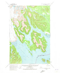
1948 Map of Mount Fairweather B-2
USGS Topo · Published 1973About this map
Glacier Bay National Monument dominates this coastal landscape, where the massive ice fields of Brady Glacier meet the waters of Glacier Bay and Taylor Bay. The map reveals a complex environment of active glaciation and tidal interaction, characterized by features like Abyss Lake and the shifting currents of Inian Pass. The southern portion of the sheet transitions into the Tongass National Forest, illustrating the overlap of these two significant federal designations near the Inian Islands.
Find a feature on this map
16 named features on this map. Tap any name to fly to it.
Don’t see what you’re looking for? This feature index may not catch every label — zoom into the map to look around manually.
Map Details
Editions of this 1948 Mount Fairweather B-2 Map
2 editions found
Other maps of this area

1948 · Mount Fairweather A-2
USGS Topo · 1:63,360

1948 · Mount Fairweather B-1
USGS Topo · 1:63,360

1948 · Mount Fairweather B-2
USGS Topo · 1:63,360

1948 · Mount Fairweather A-1
USGS Topo · 1:63,360

1948 · Mount Fairweather C-1
USGS Topo · 1:63,360

1948 · Mount Fairweather C-2
USGS Topo · 1:63,360

1949 · Mount Fairweather C-1
USGS Topo · 1:63,360

1950 · Mount Fairweather C-2
USGS Topo · 1:63,360

1951 · Mt Fairweather
USGS Topo · 1:250,000

1954 · Mount Fairweather A-1
USGS Topo · 1:63,360