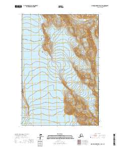
2017 Map of Mount Fairweather C-3 NE
USGS Topo · Published 2017About this map
The Fairweather Range and Saint Elias Mountains dominate this 2017 survey of the Alaskan wilderness. Encompassing a significant portion of Glacier Bay National Park, the landscape is defined by the massive slow-moving ice of Reid Glacier in the north and the expansive Brady Glacier to the south. These ice fields are punctuated by nunataks—isolated peaks of rock projecting through the glacial surface—including Contact Nunatak and Heather Nunatak. The elevation climbs sharply toward rugged heights like Mt Friable and July Fourth Mtn. This map provides a detailed look at the glacial retreat and topographical features of one of the most remote sections of the Hoonah-Angoon area, where the terrain is governed entirely by natural forces and ice-driven geography rather than human settlement.
Find a feature on this map
13 named features on this map. Tap any name to fly to it.
Don’t see what you’re looking for? This feature index may not catch every label — zoom into the map to look around manually.
Map Details
Editions of this 2017 Mount Fairweather C-3 NE Map
This is the sole edition of this map. No revisions or reprints were ever made.
Other maps of this area

1948 · Mount Fairweather D-2
USGS Topo · 1:63,360

1948 · Mount Fairweather C-2
USGS Topo · 1:63,360

1950 · Mount Fairweather D-2
USGS Topo · 1:63,360

1950 · Mount Fairweather C-2
USGS Topo · 1:63,360

1951 · Mt Fairweather
USGS Topo · 1:250,000

1961 · Mount Fairweather C-3
USGS Topo · 1:63,360

1961 · Mount Fairweather D-3
USGS Topo · 1:63,360

1961 · Mt Fairweather
USGS Topo · 1:250,000
2017 · Mount Fairweather C-3 NW
USGS Topo · 1:25,000
2017 · Mount Fairweather C-3 SE
USGS Topo · 1:25,000