
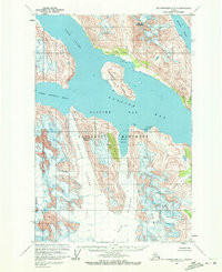
1961 Map of Mount Fairweather D-3
USGS Topo · Published 1966About this map
Glacier Bay National Monument dominates this mid-century survey, capturing a dramatic landscape of active tidewater glaciers and deep maritime inlets. This topographic study reflects data collected by the Geological Survey and USC&GS between 1948 and 1961, documenting the icy reaches of Glacier Bay before modern retreat altered the coastline. Massive ice flows including the Lamplugh Glacier and Reid Glacier are shown pushing toward Reid Inlet, while the Hugh Miller Glacier and Scidmore Glacier descend from high peaks in the southeast. Notable maritime features such as Russell Island and Tarr Inlet provide critical reference points for the shifting ice fronts of this era. Rising above the eastern shoreline, Mount Abdallah stands as a prominent landmark overlooking the waters of Rendu Inlet and the Romer Glacier.
Find a feature on this map
17 named features on this map. Tap any name to fly to it.
Don’t see what you’re looking for? This feature index may not catch every label — zoom into the map to look around manually.
Map Details
Editions of this 1961 Mount Fairweather D-3 Map
2 editions found
Other maps of this area

1948 · Mount Fairweather D-2
USGS Topo · 1:63,360

1948 · Mount Fairweather C-2
USGS Topo · 1:63,360

1950 · Mount Fairweather D-2
USGS Topo · 1:63,360

1950 · Mount Fairweather C-2
USGS Topo · 1:63,360

1951 · Mt Fairweather
USGS Topo · 1:250,000

1952 · Skagway
USGS Topo · 1:250,000

1961 · Mount Fairweather D-4
USGS Topo · 1:63,360
1961 · Skagway A-6
USGS Topo · 1:63,360

1961 · Mount Fairweather C-4
USGS Topo · 1:63,360

1961 · Mount Fairweather C-3
USGS Topo · 1:63,360