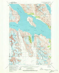
1961 Map of Mount Fairweather D-3
USGS Topo · Published 1972About this map
Glacier Bay National Monument dominates this mid-century survey, showcasing a landscape of active ice and deep marine fjords before the modern era of rapid glacial retreat. Centered on Russell Island, the map documents the convergence of several massive ice flows including the Lamplugh Glacier, Reid Glacier, and Hugh Miller Glacier. The geography here is defined by tidal inlets like Johns Hopkins Inlet and Tarr Inlet, where the ice meets the sea under the peaks of Mount Abdallah and Mount Parker. This record reflects the condition of the bay as it was observed in 1961, providing a baseline for researchers and historians studying the changing shoreline and ice positions within this protected Alaskan wilderness. Small features like Ibach Point and Ptarmigan Creek offer localized points of reference amidst the overwhelming scale of the ice fields.
Find a feature on this map
17 named features on this map. Tap any name to fly to it.
Don’t see what you’re looking for? This feature index may not catch every label — zoom into the map to look around manually.
Map Details
Editions of this 1961 Mount Fairweather D-3 Map
2 editions found

Other maps of this area

1948 · Mount Fairweather D-2
USGS Topo · 1:63,360

1948 · Mount Fairweather C-2
USGS Topo · 1:63,360

1950 · Mount Fairweather D-2
USGS Topo · 1:63,360

1950 · Mount Fairweather C-2
USGS Topo · 1:63,360

1951 · Mt Fairweather
USGS Topo · 1:250,000

1952 · Skagway
USGS Topo · 1:250,000

1961 · Mount Fairweather D-4
USGS Topo · 1:63,360
1961 · Skagway A-6
USGS Topo · 1:63,360

1961 · Mount Fairweather C-4
USGS Topo · 1:63,360

1961 · Mount Fairweather C-3
USGS Topo · 1:63,360