
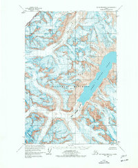
1961 Map of Mount Fairweather D-4
USGS Topo · Published 1966About this map
The Glacier Bay National Monument dominates this coastal Alaskan landscape, where the ice-dominated geography of the Fairweather Range meets the deep waters of the Pacific. At the heart of the sheet, Johns Hopkins Inlet serves as the terminus for a massive network of ice flows, most notably the Johns Hopkins Glacier and the Margerie Glacier. These frozen rivers are fed by high-altitude snowfields surrounding peaks like Mt Turner on the international boundary and Mount Abbe to the south.
Find a feature on this map
20 named features on this map. Tap any name to fly to it.
Don’t see what you’re looking for? This feature index may not catch every label — zoom into the map to look around manually.
Map Details
Editions of this 1961 Mount Fairweather D-4 Map
2 editions found
Other maps of this area

1951 · Mt Fairweather
USGS Topo · 1:250,000

1952 · Skagway
USGS Topo · 1:250,000

1961 · Skagway A-7
USGS Topo · 1:63,360
1961 · Skagway A-6
USGS Topo · 1:63,360

1961 · Mount Fairweather D-5
USGS Topo · 1:63,360

1961 · Mount Fairweather C-4
USGS Topo · 1:63,360

1961 · Mount Fairweather C-3
USGS Topo · 1:63,360

1961 · Mount Fairweather C-5
USGS Topo · 1:63,360

1961 · Mount Fairweather D-3
USGS Topo · 1:63,360

1961 · Mt Fairweather
USGS Topo · 1:250,000