
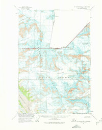
1961 Map of Mount Fairweather D-5
USGS Topo · Published 1966About this map
Mount Fairweather and the towering peaks of the Fairweather Range dominate this northern Alaskan landscape during the early 1960s. This survey, compiled from 1948 and 1961 aerial photography, documents the massive ice systems within Glacier Bay National Monument and across the international boundary between Alaska and British Columbia. The map illustrates a high-altitude wilderness where naming conventions reflect the raw environment, seen in features like Desolation Valley and Desolation Glacier. Large ice flows including the Margerie Glacier, Fairweather Glacier, and Johns Hopkins Glacier are depicted with detailed contouring, showing their reach toward the coast. Notable markers like Mt Root and Mount Quincy Adams serve as fixed points along the Canada-United States border, providing essential survey data for this remote portion of the Saint Elias Mountains.
Find a feature on this map
19 named features on this map. Tap any name to fly to it.
Don’t see what you’re looking for? This feature index may not catch every label — zoom into the map to look around manually.
Map Details
Editions of this 1961 Mount Fairweather D-5 Map
2 editions found
Other maps of this area

1951 · Mt Fairweather
USGS Topo · 1:250,000

1952 · Skagway
USGS Topo · 1:250,000

1961 · Skagway A-7
USGS Topo · 1:63,360

1961 · Mount Fairweather D-4
USGS Topo · 1:63,360

1961 · Mount Fairweather D-6
USGS Topo · 1:63,360

1961 · Mount Fairweather C-4
USGS Topo · 1:63,360
1961 · Mount Fairweather C-6
USGS Topo · 1:63,360

1961 · Skagway A-8
USGS Topo · 1:63,360

1961 · Mount Fairweather C-5
USGS Topo · 1:63,360

1961 · Mt Fairweather
USGS Topo · 1:250,000