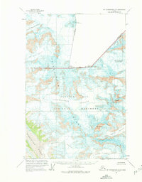
1961 Map of Mount Fairweather D-5
USGS Topo · Published 1975About this map
The Canada United States border cuts across high mountain peaks in the early 1960s, marking the northern reaches of the Fairweather Range. This survey captures a landscape dominated by massive ice fields and steep terrain within Glacier Bay National Monument, where the international boundary is defined by prominent summits like Mount Fairweather Boundary Peak 164 and Mount Quincy Adams Boundary Peak 163.
Find a feature on this map
18 named features on this map. Tap any name to fly to it.
Don’t see what you’re looking for? This feature index may not catch every label — zoom into the map to look around manually.
Map Details
Editions of this 1961 Mount Fairweather D-5 Map
2 editions found
Other maps of this area

1951 · Mt Fairweather
USGS Topo · 1:250,000

1952 · Skagway
USGS Topo · 1:250,000

1961 · Skagway A-7
USGS Topo · 1:63,360

1961 · Mount Fairweather D-4
USGS Topo · 1:63,360

1961 · Mount Fairweather D-6
USGS Topo · 1:63,360

1961 · Mount Fairweather D-5
USGS Topo · 1:63,360

1961 · Mount Fairweather C-4
USGS Topo · 1:63,360
1961 · Mount Fairweather C-6
USGS Topo · 1:63,360

1961 · Skagway A-8
USGS Topo · 1:63,360

1961 · Mount Fairweather C-5
USGS Topo · 1:63,360