
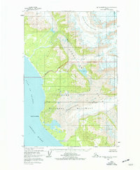
1961 Map of Mount Fairweather D-6
USGS Topo · Published 1966About this map
Glacier Bay National Monument dominates this coastal survey, where the icy flow of Desolation Glacier and Otter Glacier meet the rugged shoreline of the Pacific Ocean. This 1961 edition was compiled using photogrammetric methods from aerial photography and hydrographic data, providing a snapshot of the dynamic glacial landscape before it was redesignated as a national park. The prominent headland of Cape Fairweather serves as a navigational landmark along the Gulf of Alaska, while the inland terrain is marked by the heights of Mt. Escures. The map documents a wilderness interior devoid of roads or trails, defined by the Indefinite Boundary of shifting ice fields and the winding path of Sea Otter Creek as it drains toward the coast.
Find a feature on this map
10 named features on this map. Tap any name to fly to it.
Don’t see what you’re looking for? This feature index may not catch every label — zoom into the map to look around manually.
Map Details
Editions of this 1961 Mount Fairweather D-6 Map
2 editions found
Other maps of this area

1951 · Yakutat
USGS Topo · 1:250,000

1951 · Mt Fairweather
USGS Topo · 1:250,000

1952 · Skagway
USGS Topo · 1:250,000

1959 · Yakutat A-1
USGS Topo · 1:63,360

1959 · Yakutat
USGS Topo · 1:250,000
1961 · Mount Fairweather D-7
USGS Topo · 1:63,360

1961 · Mount Fairweather D-5
USGS Topo · 1:63,360
1961 · Mount Fairweather C-6
USGS Topo · 1:63,360

1961 · Skagway A-8
USGS Topo · 1:63,360

1961 · Mount Fairweather C-5
USGS Topo · 1:63,360