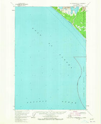
1961 Map of Mount Fairweather D-7
USGS Topo · Published 1965About this map
Glacier Bay National Monument borders the rugged coastline where the Pacific Ocean meets the northern reaches of the Gulf of Alaska. This 1961 field-annotated survey captures a landscape dominated by the advancing and retreating ice of the Grand Plateau Glacier, which flows toward the sea in the northeastern corner of the map. The cartography highlights an Indefinite Boundary along the monument's edge, reflecting the shifting nature of this coastal wilderness before more modern shoreline surveys were finalized. Depth soundings across the marine areas provide a detailed look at the underwater topography of these glacial waters, recorded just as photogrammetric methods from 1948 aerial photography were being integrated into the official record of this remote Alaskan territory.
Find a feature on this map
7 named features on this map. Tap any name to fly to it.
Don’t see what you’re looking for? This feature index may not catch every label — zoom into the map to look around manually.
Map Details
Editions of this 1961 Mount Fairweather D-7 Map
2 editions found
Other maps of this area

1951 · Yakutat
USGS Topo · 1:250,000

1951 · Mt Fairweather
USGS Topo · 1:250,000

1952 · Skagway
USGS Topo · 1:250,000

1959 · Yakutat A-1
USGS Topo · 1:63,360

1959 · Yakutat
USGS Topo · 1:250,000

1961 · Mount Fairweather D-6
USGS Topo · 1:63,360
1961 · Mount Fairweather C-6
USGS Topo · 1:63,360

1961 · Skagway A-8
USGS Topo · 1:63,360

1961 · Mt Fairweather
USGS Topo · 1:250,000

1961 · Skagway
USGS Topo · 1:250,000