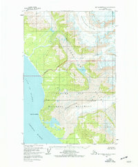
1961 Map of Mount Fairweather D-6
USGS Topo · Published 1977About this map
The coastal wilderness of Glacier Bay National Monument dominates this coastal survey, where the terrestrial landscape is largely defined by massive ice flows. Massive features such as the Grand Plateau Glacier, Desolation Glacier, and Otter Glacier descend from the heights toward the coastline, illustrating the dynamic glacial environment before significant modern retreat.
Find a feature on this map
13 named features on this map. Tap any name to fly to it.
Don’t see what you’re looking for? This feature index may not catch every label — zoom into the map to look around manually.
Map Details
Editions of this 1961 Mount Fairweather D-6 Map
2 editions found
Other maps of this area

1951 · Yakutat
USGS Topo · 1:250,000

1951 · Mt Fairweather
USGS Topo · 1:250,000

1952 · Skagway
USGS Topo · 1:250,000

1959 · Yakutat A-1
USGS Topo · 1:63,360

1959 · Yakutat
USGS Topo · 1:250,000
1961 · Mount Fairweather D-7
USGS Topo · 1:63,360

1961 · Mount Fairweather D-6
USGS Topo · 1:63,360

1961 · Mount Fairweather D-5
USGS Topo · 1:63,360
1961 · Mount Fairweather C-6
USGS Topo · 1:63,360

1961 · Skagway A-8
USGS Topo · 1:63,360