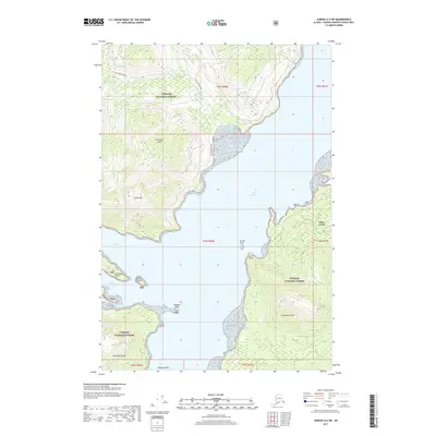
2017 Map of Juneau A-5 SW
USGS Topo · Published 2017About this map
Chichagof Island and the expansive Tongass National Forest dominate this coastal landscape, where the waters of Port Frederick meet the island's irregular shoreline. This area reflects the modern intersection of industrial access and wilderness preservation, evidenced by the Westport Mainline cutting through the northern timberlands. The settlement at Game Creek sits on the eastern shore of the port, serving as a primary point of human activity amidst the high elevations of Neka Mtn and the coastal features of Neka Bay. Navigation and maritime geography are prominent, with specific points like Burnt Point, Grassy Rock, and Chimney Rock providing essential landmarks for those traversing the bights and inlets. The presence of numerous creeks, such as Humpback Cr and Seagull Cr, underscores the hydrological complexity of this Southeast Alaskan environment.
Find a feature on this map
23 named features on this map. Tap any name to fly to it.
Don’t see what you’re looking for? This feature index may not catch every label — zoom into the map to look around manually.
Map Details
Editions of this 2017 Juneau A-5 SW Map
This is the sole edition of this map. No revisions or reprints were ever made.
Other maps of this area

1948 · Sitka D-5
USGS Topo · 1:63,360

1948 · Sitka D-6
USGS Topo · 1:63,360

1951 · Juneau
USGS Topo · 1:250,000

1951 · Juneau A-6
USGS Topo · 1:63,360

1951 · Juneau A-5
USGS Topo · 1:63,360

1951 · Sitka
USGS Topo · 1:250,000

1951 · Sitka D-6
USGS Topo · 1:63,360

1951 · Sitka D-5
USGS Topo · 1:63,360

1952 · Sitka
USGS Topo · 1:250,000

1962 · Juneau
USGS Topo · 1:250,000