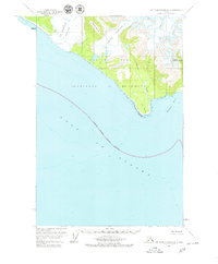
1961 Map of Mt Fairweather B-4
USGS Topo · Published 1979About this map
La Perouse Glacier and Finger Glacier dominate this coastal section of the Glacier Bay National Monument in the early 1960s. The coastline is defined by the sharp projection of Icy Point, which separates the open waters of the Gulf of Alaska from the protected reach of Palma Bay. The terrain rises sharply from the shore toward South Dome and the interior heights of Mount Marchainville, illustrating the dramatic glacial topography that characterizes this wilderness area. The survey reveals the extensive reach of the National Monument Boundary (Indefinite) as it stretched out into the gulf, marking a time when these remote shorelines were being formally documented by the U.S. Geological Survey. Sparse drainages like Kaknau Creek provide the only breaks in the heavily glaciated landscape.
Find a feature on this map
11 named features on this map. Tap any name to fly to it.
Don’t see what you’re looking for? This feature index may not catch every label — zoom into the map to look around manually.
Map Details
Editions of this 1961 Mt Fairweather B-4 Map
2 editions found
Other maps of this area

1951 · Mt Fairweather
USGS Topo · 1:250,000
1961 · Mount Fairweather A-3
USGS Topo · 1:63,360
1961 · Mount Fairweather B-3
USGS Topo · 1:63,360

1961 · Mount Fairweather C-4
USGS Topo · 1:63,360

1961 · Mount Fairweather C-3
USGS Topo · 1:63,360
1961 · Mt Fairweather B-4
USGS Topo · 1:63,360

1961 · Mount Fairweather C-5
USGS Topo · 1:63,360

1961 · Mt Fairweather
USGS Topo · 1:250,000
2017 · Mount Fairweather C-4 SE
USGS Topo · 1:25,000
2017 · Mount Fairweather C-4 SW
USGS Topo · 1:25,000