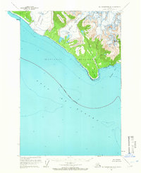
1961 Map of Mt Fairweather B-4
USGS Topo · Published 1966About this map
The coastal wilderness within Glacier Bay National Monument is defined by the proximity of massive ice fields to the Gulf of Alaska as seen in this 1961 field-annotated survey. Prominent ice masses like La Perouse Glacier and Finger Glacier dominate the rugged interior, their paths carved toward the shoreline near Icy Point. High-elevation landmarks such as South Dome and Mount Marchainville overlook the complex interplay of ice and water, where the National Monument Boundary extends into the open sea. This topographical study captures the environment before decades of glacial retreat would significantly alter the calving fronts, providing a baseline for understanding the area near Palma Bay and the drainage of Kaknau Creek.
Find a feature on this map
11 named features on this map. Tap any name to fly to it.
Don’t see what you’re looking for? This feature index may not catch every label — zoom into the map to look around manually.
Map Details
Editions of this 1961 Mt Fairweather B-4 Map
2 editions found
Other maps of this area

1951 · Mt Fairweather
USGS Topo · 1:250,000
1961 · Mount Fairweather A-3
USGS Topo · 1:63,360
1961 · Mount Fairweather B-3
USGS Topo · 1:63,360

1961 · Mount Fairweather C-4
USGS Topo · 1:63,360

1961 · Mount Fairweather C-3
USGS Topo · 1:63,360

1961 · Mount Fairweather C-5
USGS Topo · 1:63,360

1961 · Mt Fairweather
USGS Topo · 1:250,000
2017 · Mount Fairweather C-4 SE
USGS Topo · 1:25,000
2017 · Mount Fairweather C-4 SW
USGS Topo · 1:25,000
2017 · Mount Fairweather B-4 NE
USGS Topo · 1:25,000