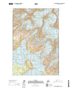
2017 Map of Mount Fairweather C-4 SW
USGS Topo · Published 2017About this map
Glacier Bay National Park dominates this section of the Fairweather Range, where massive ice fields and high peaks define the topography. The landscape is shaped by the movement of the La Perouse Glacier and S Crillon Glacier, which flow from the high elevations near Mt Dagelet and Mt Klooch. These glaciers carve through the central Great Valley, illustrating the powerful glaciological forces that characterize the Alaskan panhandle. Significant landmarks such as Ptarmigan Dome and Mid Dome provide fixed points for navigating this ever-shifting environment of ice and rock. The map captures a moment in the modern era of the park's management, showing the complex interplay between perennial ice and high-altitude terrain before significant seasonal changes.
Find a feature on this map
15 named features on this map. Tap any name to fly to it.
Don’t see what you’re looking for? This feature index may not catch every label — zoom into the map to look around manually.
Map Details
Editions of this 2017 Mount Fairweather C-4 SW Map
This is the sole edition of this map. No revisions or reprints were ever made.
Other maps of this area

1951 · Mt Fairweather
USGS Topo · 1:250,000

1961 · Mount Fairweather C-4
USGS Topo · 1:63,360
1961 · Mt Fairweather B-4
USGS Topo · 1:63,360

1961 · Mount Fairweather C-5
USGS Topo · 1:63,360

1961 · Mt Fairweather
USGS Topo · 1:250,000
2017 · Mount Fairweather C-4 SE
USGS Topo · 1:25,000
2017 · Mount Fairweather B-4 NE
USGS Topo · 1:25,000
2017 · Mount Fairweather C-5 SE
USGS Topo · 1:25,000
2017 · Mount Fairweather B-4 NW
USGS Topo · 1:25,000
2017 · Mount Fairweather C-4 NE
USGS Topo · 1:25,000