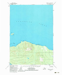
1948 Map of Sumdum A-6
USGS Topo · Published 1983About this map
Kupreanof Island dominates the southern half of this coastal survey, where the dense contours of Turn Mountain rise above the cold waters of Frederick Sound. This mid-century view, based on aerial photography from 1948, captures a landscape defined by its marine boundaries and the reach of the Tongass National Forest. The map detail follows the intricate shoreline from the northern reaches of Keku Strait past Pinta Pt to the isolated outcrop of Turnabout I. Inland, the drainage of Gunnuk Creek flows through the heavy timber and high ridges, providing a clear picture of the topography before significant modern development altered the wilderness character of the Alexander Archipelago.
Find a feature on this map
10 named features on this map. Tap any name to fly to it.
Don’t see what you’re looking for? This feature index may not catch every label — zoom into the map to look around manually.
Map Details
Editions of this 1948 Sumdum A-6 Map
5 editions found
Other maps of this area

1948 · Sitka B-1
USGS Topo · 1:63,360

1948 · Sumdum A-5
USGS Topo · 1:63,360

1948 · Sumdum A-6
USGS Topo · 1:63,360

1948 · Sumdum B-6
USGS Topo · 1:63,360

1948 · Sumdum B-5
USGS Topo · 1:63,360

1948 · Petersburg D-6
USGS Topo · 1:63,360

1948 · Port Alexander D-1
USGS Topo · 1:63,360

1948 · Sitka A-1
USGS Topo · 1:63,360

1948 · Petersburg D-5
USGS Topo · 1:63,360

1951 · Sitka
USGS Topo · 1:250,000