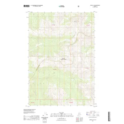
2021 Map of Juneau A-2 SW
USGS Topo · Published 2021About this map
The Tongass National Forest defines this high-elevation coastal landscape, where the administrative boundary between the Juneau City and Borough Hoonah-Angoon Census Area traverses the terrain. This 2021 survey reveals a primitive wilderness dominated by steep contour lines and glacial drainage patterns. Eagle Peak stands as a prominent landmark in the north, shedding water into the network of alpine streams below. The drainage system is anchored by the Greens Cr in the west and the King Salmon River in the east, both carving through deep valleys that emphasize the verticality of the Southeast Alaska coast. The map illustrates the intersection of vast public timberlands and maritime-influenced geography, showing the landscape as it existed before contemporary shifts in land use or climatic impacts on the local hydrography.
Find a feature on this map
11 named features on this map. Tap any name to fly to it.
Don’t see what you’re looking for? This feature index may not catch every label — zoom into the map to look around manually.
Map Details
Editions of this 2021 Juneau A-2 SW Map
This is the sole edition of this map. No revisions or reprints were ever made.
Other maps of this area

1948 · Juneau A-3
USGS Topo · 1:63,360

1948 · Sitka D-3
USGS Topo · 1:63,360

1948 · Sitka D-2
USGS Topo · 1:63,360

1950 · Juneau A-3
USGS Topo · 1:63,360

1951 · Juneau
USGS Topo · 1:250,000

1951 · Juneau A-2
USGS Topo · 1:63,360

1951 · Sitka
USGS Topo · 1:250,000

1951 · Sitka D-3
USGS Topo · 1:63,360

1951 · Sitka D-2
USGS Topo · 1:63,360

1952 · Sitka
USGS Topo · 1:250,000